


Are you old enough -- are you Canadian enough -- to remember The Spoons' 1984 hit Romantic Traffic? Well... I am. :)
Monday, August 25, 2008


Tuesday, August 12, 2008
Twice more unto the bridge, dear friends, twice more
Summer is the time to get out on the weekends and feel the soil under your feet. It’s the time to bask in the warmth of the sun, the scents of the air, the majesty of the forest full. We live in an age where we can sit in an armchair and comb the face of the world as if sitting above it like gods, and from there pick the places of our fancy to explore and indulge in.
Last week, I found (as I’m apt to) another place in the GTA left behind by time. I love to explore places like that. In this case, it was a pair of abandoned roads that meet up in the forest, in a marshy area not far from Lake Simcoe. Just a few minutes east of that lost intersection is a bridge over a river. For me, this is how you spend a summer Saturday.
I ran the idea of investigating the place past P-Doug and got an affirmation on Friday that became a qualified reluctance on Saturday morning. The radar showed something big coming in. But for myself, I didn’t care. Summer’s too short to sit around; that’s what a Canadian winter is for. I understood his reasons but I’ve never been one to eschew a hike in the drizzle or even the rain. In truth, some of the best hiking I’ve ever done has been alone on rainy days. I decided to set off on my own.
It was a nice drive, going someplace I’d never been, watching the clouds boil and change as I made my way northeasterly. I was listening to Freakonomics, if you’re familiar with it. Fascinating journey through applied statistics as I crossed the countryside in the heavy weather. When I got near my destination, I found the route blocked, supposedly by a bridge outage. How ironic. The detour took me up, across, down and around my destination like the shell of a snail. But finally, I reached the 6th Concession, and I headed down to the end.
It was raining lightly when I parked, and dosing myself liberally with bug repellant, I passed the barriers that separated the open road from the closed. The first thing I noticed was how wet the way in was. Even without the rain, it was clear that this concession line was ordinarily quite swampy. The shin-deep, water-filled depressions seemed to hold equal sway with the ordinary raised parts of the road, like a regular Morse code of water. The bottom was clay, and the land was flat; little drainage and a tight seal below. No wonder the place was abandoned; I doubt any of it south of the barrier had been cleared. These were roads the community could do without, and evidently, at some point in the last couple of generations, they ultimately did.


As I walked, there was nothing to suggest anyone had been there in ages, aside from the intermittent paired wheel ruts. They were smooth; there was no vehicle track, no foot print, no garbage, no cigarette butts. It was astounding. I’ve never seen a track that open that showed so little evidence of human presence.
I guess it took me about 15 minutes to reach the intersection. It was a curious junction of roads reduced in width to that of a single car. The one I was on ended there, only to have the suggestion of a continuation ten or so metres to the west; the road I met was doglegged by three or four metres itself; further north on the east side. A drainage pipe of some sort ran diagonally across the intersection. It must have been buried once, but time had revealed and ruined it. From there, I headed east towards the bridge.


I guess it was something like fifteen paces on ‘dry’ (call it raised, really) ground, followed by at least as many through the puddles, some of them knee-deep. Even in Milton the week before, I’ve never seen the like. What would probably have been a three minute walk become closer to ten as I made my way through the warm drizzle. I passed a curious sign that read “SLOW” at one point before a very considerable puddle, matched by another on the far side. I wondered just who they’d intended it for.

I’d like to take a moment to congratulate myself. I always bring my cameras on these expeditions, but ordinarily I’m too caught up in the exploration to think of them when I’m nearing my goal. But this time, I had the presence of mind to turn on the video function as I approached the bridge, and I recorded it, as I saw it, for the first time, wandering around on it, exploring what had once been a common place but was now abandoned to the forest.


I have no idea when 6th Concession and Brewster Road – upon which the bridge lies – were closed. But if you told me that bridge hadn’t seen regular traffic since the 1970s, I’d have no trouble believing it. It’s worn through at the edges; large holes look right through to the fast-flowing river a few metres below. No idea of the age of the bridge, myself. But it was really something to have spotted it on GoogleMaps, to go there, seek it out, see it with my own eyes, stand upon it on my own two feet. I spent about half an hour wandering back and forth on it, capturing it in three dimensions in paired photographs, first in colour and then in infrared. After a bit, I eased down through the woods at the southwest side and shot the bridge from below. Then it was time to explore the river.
I picked my way through the forest beside the road, past abandoned rolls of the same chicken wire that now guard the sides of the bridge, to gnarled trees and finally the firm bank at the sudden lip of the river. There in the rain I stripped and helped myself to the water, overhung by low-limbed trees. The water was surprisingly warm and deepened quickly only a couple of yards out. I sat on the shallow lip at the bank and simply luxuriated in the privilege.
I guess I was there about half an hour. Eventually, I decided to drift back to town; I thought if I were early enough, I might be able to meet up with P-Doug at one of our chosen watering holes and share what I’d discovered. I made my way back to the car and headed back to the city. As I headed down the 404 through Aurora, the weather he’d dreaded hit, and real rain began to fall… but it hadn’t troubled me on my wanderings. I called him from the road (briefly becoming one of the cell phone shitheads I abhor) and made arrangements to meet him at that pub, where I showed him the shots of the trek over a few beers and too much food.
That wasn’t the end of it, though. The following morning, it struck me to ask him if he’d care to explore the place now that the weather was slightly more amenable. I called him up a little after 11 and put the suggestion to him, and he was surprisingly agreeable. He picked me up a little while later and off we went, listening to the news of a large explosion in the north central part of the city that morning that had closed off the 401. I would remark later how little effect it had on us, for an event so large.
We zigzagged across the countryside, north, east, north, east… making our way there by a route not entirely tracing the way I’d gone the day before. We parked down by the barriers, deeper down the road than I’d driven, and, once again chemically arming ourselves against the mosquitoes, we headed south. I led, kicking through the warm water of the puddles, this time unpockmarked by raindrops, though the sky was still heavily cast.
As we walked, I realized just why I’d been so anxious to share the place with P-Doug… it’s that fresh perspective you get from another person. Things in his experience but not mine bubbled up to explain things I hadn’t even imagined needed explaining. So much of the character of the place, he realized, could be put down to the local snowmobile clubs, who’d kept the place open for their own winter use. They’d put the up the signs. They’d cut down the saplings that would have devoured the clearances. They’d put up the chicken wire to prevent riders from careening off the otherwise unguarded sides of the bridge. I wanted, I needed, that other pair of eyes to help me see more about this interesting place.
When we reached the intersection, we wandered about as far west as I’d gone, to the last leg of 6th Concession heading south to the river. We didn’t wander it but we did earmark it for later. Then we headed east. I noticed shotgun shells from previous seasons. And for the first time, we saw tracks on the road. So much for unspoiled. Someone had been by since the rains.
When P-Doug saw the "SLOW" sign that had vaguely mystified me, it held no such mysteries for him. Coming from the north as he does, he immediately identified it as a warning to the snowmobilers who would use the routes in the wintertime. That would never have occurred to me in a month of summery, barefoot Sundays. I felt slightly ashamed as a Canadian. :)
We made our way through the slippery puddles to the bridge, where, again, I videoed the arrival, and P-Doug’s reaction. We spent about a quarter of an hour at the bridge before deciding to indulge in the river. He elected to return to the intersection and head down the overgrown last leg of 6th Concession to a landing on the river. So, we headed there. The road in was surprisingly well-defined; to me, from above, it had appeared to be largely filled in. The road veered away from the straight, running sort of alongside the river, so eventually we had to abandon it and make our way through the woods to the landing. The landing, it turned out, was not the sand or rock we’d anticipated, but plants the height of a man standing in shin-deep water, reaching out for ten or fifteen metres into the water. We made our way to the edge, then back to the woods to undress to get into the water. It was cold, a lot colder than it had been for me the day before. It dropped off immediately, and there was no place to sit, and no place to go where the water wasn’t immensely deep. One thing P-Doug noticed while we were there that I’d entirely missed was the utter silence of it. Not just that the deep river made no sound whatsoever, but there were no birds, either. Brought to my attention, it was faintly unnerving, and came to my mind every so often as long as we were there on the roads. But that location wasn’t the best in any regard. We essentially just sort of stood there, ribs-deep in rather cold water, for ten or fifteen minutes, before leaving to find a bank more like the one I’d found the day before. There was none to be found just there, so we dressed again and headed back towards the bridge and the spot I’d found so pleasant on Saturday.
When we got there, I headed into the water at once. P-Doug lingered a bit, uncertain of the water, I suppose. It was markedly warmer than it had been upstream. After a few minutes, he stepped into the water too. Almost no sooner had he done so than we heard the telltale roar of approaching ATVs. Literally within two or three minutes of our having gotten into the river, along they came, just within sight through the trees. I saw two; P-Doug reckoned there were three. We were out of sight and not overly concerned, but, of course, they stopped at the bridge to smoke or drink or something, and for the next fifteen minutes we leaned against the bank and listened to them hoot and holler. I have to say it… I’m getting a little sick of these ATV cretins. Is there no place left in Canada wider than you can spread your arms where they won’t insist on tearing up the place, filling the world with their tracks, noise, and pollution? Can’t they enjoy the wilderness for what it is? If they want to go rip-snorting around, can’t they do it in their cars on the 400-series highways? Do they have to ruin the serenity of what little nature is left adjoining our cities? Honest to God.
Finally, “Darrell and my other brother Darrell”, as P-Doug put it, “fucked off”, and we could finally wander the water’s edge a little. It was deep, and fairly warm, but a light rain had begun to fall and dropped the temperature considerably. What’s already been a very mild summer began to feel like early spring, and more than once, I caught myself shivering. But we’d worked hard to find the place, and by God, we’d earned the right to enjoy it. So we stayed longer than comfort really dictated, just out of obstinacy, I suppose, and after 45 minutes or so, we decided to call it a hike and head back.
It wasn’t the sunniest place I’ve been, or the most challenging in terms of hiking, but it was truly beautiful, and the bridge genuinely intriguing (at least to me). And, personally, I rather enjoyed the sensual pleasures of the muddy, clay-bottomed puddles that formed half the journey on the abandoned roads. I don’t know if I’ll ever be back there, but sure know I’ll always remember the place with a certain fondness.
Sunday, August 10, 2008
The empty 401
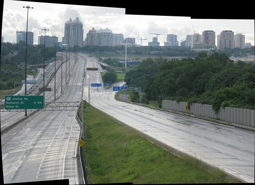
The explosion of a propane facility in the west end has closed the 401 today from the 404 (just behind me) to the 400. I've never seen anything like this. When we were passing over the highway and looked at it, we were so struck by seeing the 401 without traffic for the first time that we had to stop and get some shots. This view looks west from Don Mills Road towards Leslie Street.
Thursday, August 07, 2008
In the trees, of the trees
Monday being a holiday hereabouts, and my friends either out of town or communication, I was kind of at loose ends. So I made some plans to just get out, get some earth under my feet, and see something new. Well, something old. I like to explore places that have been abandoned, left behind. Place that once were "places", but are no more, if you see what I mean.
Greater Toronto's in a state of flux. Once just a small town surrounded by farms, it's grown into one of the continent's principal metropolitan areas. People migrate, farmland becomes subdivision. Patterns of land and people change. Thanks to things like GoogleMaps, it's not that hard to soar over the landscape and seek out the places that have been left behind. I found one last weekend and went to explore it.
Situated in Milton north of the 401 and just a little east of Hwy 25, it's an intriguing chunk of territory that, a generation or two ago, must have been settled farmland, or at least attached to it. I've seen lots of abandoned concession and range roads in the past 20 years or so, but I think this is the first time I've encountered an actual abandoned intersection. Yes, in the middle of the forest, a concession and range road meeting up, without lights or stop signs or buildings. Just two thin, cleared lines among the forest trees. I imagine that an intersection like, say, Dufferin and St. Clair must have looked like this once. One became a busy city intersection. The other was returned to nature. Well, more or less.


The roads are still open; they're no more than a single car width now, if they were ever more than that. I parked at the west end and began the walk. The road was full ruts, deep and muddy; the kind of thing I find enjoyable in my style of hiking. Not far in, I found a section of the Bruce Trail leading away to the north; a bit further along, the southbound part of the Trail as well. I stayed with the road, however, passing a clearing, a shallow pond, and any number of rises and valleys. It took me about half an hour to make my way to the intersection, which was surprisingly wide, and featured a large pool that was probably a couple of feet deep. At that point I was more interested in checking out the other road, so I skirted the pool rather than wading it.


 Try to imagine this intersection as it might have been... or might yet be, one day... at the heart of a busy city scene.
I didn't go far up the other road; I stopped for a while to sit and enjoy the setting. The air was still; there was hardly a sound. Near me on the road was another big pool, and this one I did attempt as I headed back. Just then, I heard behind me the sound of an approaching vehicle, and I scrambled out, for fear I might get run over. A truck came over the rise, and behind it an ATV. The ATV used the little side road to get around the truck, and its rider stopped to talk with me while we watched the guys in the truck decide whether or not to take on the giant puddle (which they did with aplomb, the driver calling back to us, "Where's the fun in that?"). The ATV headed off south, and then east; the truck turned west, down the road from which I'd come. I skirted the pool at the intersection again, crossing through the forest, and headed back. After ten or fifteen minutes, I heard the truck coming back, and I stepped off the road. It was at the location of the first big pond, which is off the road on the north side. They turned towards it, clearly considering driving through it, but prudence got the better of them and they stayed with the road. They saw me and we shared a laugh and I said I didn't blame them.


On the way in to the road, I'd noticed what looked like an abandoned school on the corner, and that was confirmed when I spoke with the fellow on the ATV. So I stopped there for a few minutes and took a few shots of the sad decay of the place. Later on, I found out a little about it on the net. It was Speyside Public School, and it was built in 1960 and closed (as such) in 1986. Afterwards, it was a Catholic high school for a couple of years, and then a teacher's college for York University till the mid-90s (in fact, it still has a York University entrance sign on it). After that, it was closed for good. It made me sad to think of the people who must have passed through it over the years; a place so full of life once, now just silent and increasingly overgrown.


I also discovered there's a "royal" oak there. Acorns from England were brought over and planted, in the nearby village of Dublin, to celebrate the coronation of King George VI in 1937. It was soon moved about 20 years later to its current location when the new school was built. I took pictures of nearly everything else, but missed the oak! I mean to go back and take some pictures of it; soon, or maybe in the fall.
--------------------------------------------
ADDENDUM:
August 25th
Last Friday (August 22), P-Doug and I went out to Milton and I got the following pix of the Royal Oak for you. :)


Subscribe to:
Posts (Atom)