


Sunday, May 31, 2009
The things you hear when there's nobody around...
I'm here at work on a Sunday because there are things I need to get out of the way, and I'm listening to an online instrumental jazz station. Every so often, they run an ad. I just heard one for — believe it or not — the CIA. They just ran an ad for the US Central Intelligence Agency. I always thought these guys recruited by watching the universities for signs of brainiacism or something. But radio ads aimed at upright, pipe-smoking, slipper-wearing William F. Buckley types? No wonder the collapse of the Soviet Union came as such a surprise. :)
Wednesday, May 27, 2009
McKinnon at last
P-Doug and I have been intending to make a trek up a closed road called McKinnon Road since early this spring. It’s a bit west of Barrie and runs alongside the Nottawasaga River. We actually undertook the trip early in April, but the weather was against us. By the time we got there, it was actually snowing! Pretty much every weekend since then that it’s been proposed, the weather’s been cold and wet. Finally, this weekend past, we got decent weather and gave it a shot on Sunday.
P-Doug picked me up a little after 10 in the morning, and we were at the end of the driveable road a bit before noon. That in and of itself is further than we got last time, when the road just beyond the pavement was flooded and closed to cars.
It wasn’t a promising start. Immediately after the closure of the road was a huge, swampy puddle, and visible beyond that was another. Much as I enjoy wet, soft soil underfoot on our explorations, even I thought that a mile or more of that would be slow going and not very enjoyable. Nevertheless, we decided to give it a go. I was on the point of tucking my sandals into the cargo pocket of my shorts, but at the last moment I elected to leave them in the car and undertake the trek without recourse to them, come what may.


The further we went, the more amenable the path became. We emerged from the swampiness after about twenty minutes. We saw some interesting things… a patch of trees standing in water that reminded us of the Louisiana bayou, where P-Doug spotted a raccoon washing some grub and then swimming away… snowmobile paths marked off with tall orange stakes… a couple of guys speaking French as they sat beside the river, possibly fishing (they were the only other people we actually saw that day, though there were plenty of boot prints on the path)...

We took out time, but after about an hour, we saw one of the things we’d really come to see. It was a bridge we’d seen in the Google Maps shots of the river. In those pictures, it seemed to both of us, we were looking at a crude wooden structure… something so rudimentary it seemed certain to me to be something private and long abandoned. Imagine our amazement when we found, instead, an elaborate and gorgeous steel bridge! Still in fine condition, with an intact concrete roadbed and aluminum paint, it seemed almost hilariously out of place, serving a road that by now is barely discernible even in aerial photos.


When we stood on it, P-Doug noticed that it had a rare feature: in the concrete along the north side was written the name of the bridge, the date of its construction (September, 1927), and the names of the men responsible for its construction. It was a rare, precise, personal connection with the past. Why it was built to serve a road in such a place with such hopeless drainage and unlikely future, we can only guess. But it was, and it seems a real shame it stands there alone, essentially useless.


We walked a little beyond it. We saw what looked like the remnants of the pillars of someone’s driveway gate. We shot the beautiful bend of the river, and then began our way back. Just east of the river, I broke off from P-Doug for a moment to try to reach the sandy banks. Stinging nettles finally defeated me and I came back to my friend on the bridge. We lingered for a bit, and then retraced our course.


I hope we go back. It really was a lovely, variable place, full of interesting sights and possibilities. Furthermore, for me, it was a fantastic hike, three hours and at least as many miles over just about every imaginable surface: swamp, mud, rocky streams, clay, sand, grass, forest floor, ferns, concrete… In Germany and Austria, they have the institution of “barefoot parks”. The idea behind them is related to reflexology, and in practical terms, they give people a chance to explore nature and its textures by walking barefoot over and through it. They seem a bit contrived to me. McKinnon Road, on the other hand, I think would serve that purpose magnificently, and naturally, without any sort of embellishment. If you’re amenable to that sort of hiking, and I know there are others who are, I’d encourage you to give McKinnon Road a try on some warm day.
Thursday, May 14, 2009
The province of Turks and Caicos?
This is from the March 2nd, 2009 issue of The Ottawa Citizen. I've been hearing about this proposal since I was in high school. We want it, they seem to want it... why does it never bloody happen? Nova Scotia's legislature even passed a vote, in 2004, to let the Turks and Caicos join that province if they ever join Confederation, sidestepping the unanimity requirement for new provinces in the Constitution (besides, with a population of only 30,000, it's unlikely the Turks and Caicos could actually form a viable province on their own).
Read on...
-----------------------------------------
The province of Turks and Caicos?
MP champions special ties with Caribbean nation to boost trade, ability to deliver aid
By Donna Jacobs, Citizen Special
March 2, 2009
Suppose Canada built itself a deep-water port in the turquoise waters of the Caribbean.
Suppose that port opened up a new market for Canadian goods -- more than 120 million people live in the Caribbean and nearby Central and South America.
Suppose Canada enhanced the port with a regional free trade zone.
Suppose Canadian ships carried northward duty-free tropical produce and products from the Caribbean and Latin America. In some locations, food rots for lack of shipping and export markets.
Suppose these ships returned with Canadian durable goods -- now scarce on southern shelves.
Suppose the port, unaffordable for Caribbean countries, boosted their standard of living and bolstered hemispheric security.
Suppose the port doubled as a Canadian military operations base for countries wanting help to patrol their waters and to interdict the Caribbean's robust trade in smuggled arms, drugs and people.
Suppose Canada used the port as an aid base when hurricanes strike.
Suppose Canada fills a vacuum of influence where China, Cuba and -- bolstered by Iran -- Venezuela have stepped in with medical aid, cheap petroleum, schools and factory construction.
Suppose Canada did all this with its usual low-key, good-cop approach to world politics and regional strife, drawing on the goodwill that comes from its 100-year trading relationship in the Caribbean. (Canada's direct investment holdings in the Caribbean-Latin American market in 2007 totalled $87.2 billion.)
For years, Edmonton East Conservative MP Peter Goldring has been campaigning for this all-purpose "Canadian platform" on South Caicos Island. The Turks and Caicos lie north of the Dominican Republic and Haiti.
In the 1970s, Turks and Caicos knocked on Canada's front door.
The English-speaking nation asked to become Canada's 11th province. It was ultimately turned down. Strange in today's multicultural Canada, says Mr. Goldring, but concerns over racial and cultural integration figured in the decision.
In the late 1980s, with some 90 per cent of their population in favour, Turks and Caicos asked again for a "special relationship" with Canada. In 2003, with 60 per cent in favour, Turks and Caicos renewed its request.
The Turks and Caicos -- comprised of two groups of islands -- are independent, but remain a British overseas territory.
For many Canadians -- and everyone else -- Caribbean life is a beach holiday. But, says Mr. Goldring quietly, "the Caribbean can get away on itself, if you do not give it care and attention."
- - -
Indeed, he's taken a lot of kidding for championing the Turks and Caicos -- similar to Edmonton in distance from Ottawa -- as a Canadian territory.
"I'm concerned that the idea is being taken too lightly," he says. "People find a lot of humour in it."
Skeptics are concerned over the prospect of massive migration from the Caribbean or the risk that winter-weary Canadians would overwhelm the islands. Mr. Goldring says both concerns can be handled -- think of Hawaii and the U.S. or of Quebec's provincially-tailored immigration standards.
And the port proposal is not merely a matter for Turks and Caicos. Ambassadors to Canada from Barbados and Cuba, and politicians in Dominica and St. Lucia, have championed more deep-water trade with Halifax which, he says, after touring the Halifax port, has "lots of capacity."
Historically, he adds, two Canadian ships used to ply between the islands. And though Canada's presence has diminished, it staged its Haiti-bound UN troops in 2004 through Turks and Caicos.
"We could have an aid program, a DART unit, an emergency aid unit. I visited Granada after Hurricane Ivan came through and it was very evident we didn't have the capacity to help."
He's visited some 10 Caribbean countries over the years. In Haiti, he toured the Montreal-based Gildan Activewear plant, which pays about 5,000 people double the minimum wage to produce clothing.
In a post-9/11 world, now contracting with global recession, he says, Canada needs to realign its trading routes and methods.
"Too much attention has been focused on the Asian Giant," he says. "And it's getting harder to get products into the U.S. We should be looking at other alternatives."
Mr. Goldring's focus dovetails with Prime Minister Stephen Harper's policy, reinvigorated with last week's announcement of more Canadian aid, more trade and further political co-operation with the Caribbean and Latin America.
Foreign Affairs Minister Lawrence Cannon just returned from Brazil. Peter Kent, minister of state of Foreign Affairs for the Americas, just returned from Guyana, Suriname and Trinidad and Tobago, host of the Summit of the Americas in April.
Beyond Canada's burgeoning trade in the region, the Caribbean has strategic importance, Mr. Goldring says: "You have to be aware of what potentially could go wrong if places like Venezuela and Cuba were forced to align themselves with Communist China.
"Canada gives aid money to China (CIDA gave $37.2 million to Chinese organizations in 2008) and China turns around and builds the schools and hospitals and sports stadia -- with their name on it -- in the Caribbean," he says. "So we have to shake our head, because that is hugely influential."
In recent years, China built a duty-free zone in St. Lucia. (The island turned to Taiwan for help in 2007, angering China and halting its hospital construction.) And in Guyana, China built the headquarters of CARICOM, the Caribbean common market, along with a convention centre.
Canada's friendship with Cuba also carries strategic benefit. While Canada "walks a line with the U.S.," which has a trade embargo on the island, the U.S. appreciates Canada "as a stabilizing element," says Mr. Goldring
"When I visited Cuba two years ago, the Cuban people said, in no uncertain terms, that they believe they're still at war with the U.S. while Canadians are very, very well-liked."
As for the military, he says the Canadian Forces sends a frigate to the Caribbean for annual military manoeuvres, making a regional base there useful.
Mr. Goldring is right: Canada does need to take the Caribbean more seriously.
Tuesday, May 12, 2009
Ireland Park, Toronto
Matching a set of Rowan Gillespie's statues in Dublin, called "The Departure", this set in Toronto, called "The Arrival", commemorates the 38,000 Irish famine emigrants who arrived here in Toronto in 1847, at the foot of Bathurst Street, at what is now called Eireann Quay. The park was opened by Irish President Mary McAleese in 2007.
Wednesday, May 06, 2009
She's leaving
For nearly three and a half years now, I've lived in a house with a strong roof. No matter what kind of storm was going on high over my head, the torrent was funneled down a gutter to a rain barrel, where it was organized, useful, and all that chaos made sense. It was a good place to be.
My boss has resigned, effective near the end of the month. I'm losing that roof, the shelter, the way things came down making sense. I'm not looking forward to it.
She's got good reasons to go. Better than the garden variety, 'better opportunity' reasons you get 95% of the time. I can't fault her. I'm just depressed that it has to be this way. But it does.
There was a lot of patience, and a lot of learning. I came in here thinking I pretty much knew all there was to know about my job. I spent the first year messing up – barely even aware I was messing up – and didn't do well on my first review. But she took it upon herself to teach me the skills I needed to be more professional. I don't think I ever got proficient, but I'm better than I was. I check things now, I search deeper, I go back over things. Stuff still slips through the cracks, but a lot doesn't – I know, because I'm the one finding those mistakes. Anyway, I'm more aware now, and she's to thank for that.
I feel like I'm losing a friend. People can stay in touch, I know, but work was really what we had in common, and I'm not sure how to maintain that now. We didn't do much outside work... she was my boss, I was her report; there had to be some kind of distance just to maintain the working relationship. But still, there was more to it. I hadn't realized, quite, how much I looked forward to her coming in in the morning... how I tried to have one or two little things out of the way, just in case she asked. Even if we didn't chat long, she was here. Even if we only really went to lunch a few times a month, the option was there.
Most of what I found to look forward to in this place is going to disappear, and it's going to be what downstairs was... a job, in a sea of familiar-looking strangers. Part of the sense of home I've had here is going to disappear.
There are new opportunities, and maybe I will grow accustomed to them, and even eventually enjoy them. But I'm never going to like how they came about.
Tuesday, May 05, 2009
Abandoned Ford Drive
Saturday morning, just for the grits and shins, I headed down to Oakville to shoot some more abandoned stretches over Joshua Creek. Many years ago, very early in the 90s, I had a penchant for studying maps of the GTA and I noticed a little gap in one of the roads, where it crossed a stream. When I went there, I found what I hoped I'd find: an old abandoned bridge, probably built in the 50s or 60s and abandoned in the 70s or 80s. I've blogged about it; it's here.
Just a little south of that, on what is actually the same road, there's another abandoned bridge over that same creek, and then another stretch just a few yards further south still. The first is recent enough that I can remember, vaguely, passing down that stretch early in the 90s. The other seems to have been officially out of action for a rather long time.
Named for the car plant it skirts, Ford Drive is more or less a southern extension of Ninth Line. When I got my license at the end of the 80s, it still cut straight south before making a gentle westerly swing to bridge Joshua Creek and then abruptly cross some railroad tracks and dive down Maple Grove Drive. Sometime in the 90s, it was rerouted to the east, completely avoiding the creek (and thus, abandoning the stretch with the bridge), and severing its connection with Maple Grove Drive, which now stops at the tracks and no longer crosses them – according the maps, anyway.
South of that stretch is another I noticed, with another bridge over Joshua Creek. I'm not 100% sure but I'm about 90% convinced that this was actually once the course of Royal Windsor Drive, back when it had a level crossing with those railroad lines. But that must have been a very long time ago. I have access to maps of that part of Oakville going back to 1970, and the huge bridge over the tracks that's there now was also already there back then. So this stretch must have been abandoned no later than when The Beatles were still sending hits up the charts; possibly earlier than that.
I explored the old stretch of (what I believe to be) Royal Windsor Drive first. It's still in surprisingly good shape; arguably, better than old Ford Drive, which hasn't even been off the grid 20 years yet. I think it's being routinely used to service the hydro lines and/or the rail tracks at its eastern end. Passing back, I saw a garter snake; the second snake I've seen in just a few weeks. Years and years go by between snake sightings for me. Maybe it's a good sign for the environment.
To get to old Ford Drive, I had to cross a few yards of marshy ground, but that was accomplished easily enough. I wandered up as far as I could, around the bend, to where Ford now has an upper parking lot that assumes what used to be the road. On my way back, I encountered a couple of dogs. One, a German shepherd, ran just about up to me before turning back. They both had collars and 'kerchiefs on, but I never saw or directly heard the person(s) I assume they must have been with... they turned around and headed back to someone; that's clear. Later I heard a few heavy twigs snap, and that's usually a good indication there's a human around. When I crossed back through the marsh to old Royal Windsor, I expected to see them all, but there was no one. It was weird.
A relatively minor excursion for me as these things go, but one I can now check off my list. :)
Sunday, May 03, 2009
Ellesmere Road 1952-2009
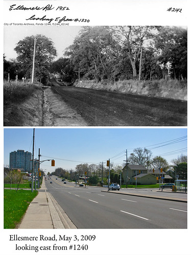
I was honestly slack-jawed when I saw the upper photo on the Toronto Public Library's website. If you're not familiar with Toronto, you probably won't think much of it... just a photo of a rural scene that's now urban Scarberia. But the thing is, Ellesemere Road is relatively mid-section in Toronto, and the view you see up top is the sort of thing I would have expected to see of the area from the 1920s or 1930s, not in the post-WWII boom. Not the way I imagined this part of town in the days of Leave It to Beaver.
The lower view is one I took this morning, from the same location, give or take a few yards. What was a farm fifty-some years ago is office space today, just off-screen to the left. Frankly, I'm not sure which view I prefer. They both have something to recommend them.
This one's for you, Jim. :)
Subscribe to:
Posts (Atom)