


This one's a three-parter, what I remember of it.
Part one: I was driving down to the southern US to visit my folks, who were apparently on vacation there. Following the directions down a lovely back road, I ended up on a dirt trail across a hilly field with tall radar towers disguised, at the top, as palm trees. I figured, whoops, must be on an army base. I guess I turned back.
Part two: With my folks, and some of their friends, at a small restaurant. At some point, I decided I needed a drink, and just stood up and went to the liquor store next door. But as I stood there, I decided I didn't need it and changed my mind.
Part three: This is the interesting one. Cut to the sunlit lobby of a fancy hotel somewhere. Feels like I'm in a movie. I'm part of a band, trying to make a decision with our manager, who is Tom Hanks. The manager has decided our band needs a second bass player, though I'm doubtful, and manager Tom is telling me that a second bass player will liberate the guitars and free them up artistically (whatever that means). So we're rehearsing guys, and some scraggly 20-something in a Lollapalooza-style t-shirt covered with band names (including the one he's currently in) is there trying out for the gig, and manager Tom tells me we should give this guy a break, because (pointing at the guy's shirt), he says, "Who in their right mind would fuck a band called 'GET CHUCK'?" And at that point, I swear to you, I woke up laughing, and I had to scribble that line down on the pad in my night table in the dark. I kid you not.
Wednesday, September 30, 2009
Friday, September 25, 2009
And now, standing in for the role of blueberry...
I bought a blueberry jelly spread yesterday for breakfasts. It's made from blueberries, but somehow they've managed to wrangle it so it's calorie-free. Suits me; all I want is the favour on the toast.
A couple of things about it. First, one of its ingredients is "red cabbage colouring". What, the natural colour of blueberries themselves wasn't sufficiently convincing?
Secondly, the expiry date is April 28th, 2011 (today's September 25th, 2009). Should something that even the microbes won't touch for another year and a half be considered as food? I'm just askin'.
Addendum: Okay, here's the really fun part. Lately, to save time, I've been eating breakfast at work. This morning, someone opened the fridge door too fast and landed my jam on the floor. I found it on the counter with the lip of the lid cracked. Wasn't pleased, but I figured, well, it's probably good for a few days, anyway. So I made toast and used it, planning on replacing it next week...
Came back into the kitchen a few minutes ago; there's my jar on the counter again, this time with a note to the effect that: "Hi, is this your jam? Blah blah blah sorry, it fell off the door and the lid broke and came off and the jam landed upside down so it's dirty..."
Ugh. :(P
Wednesday, September 23, 2009
House treatment
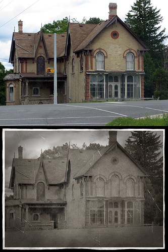
To make the faux aged shot on the bottom, there was a fair amount of retouching involved to take out modern elements, like the signal post, road lines, power lines and leads on the wall... I also had to rebuild the doorway on the porch. If you notice in the upper shot that one of the windows has been bricked in, you can also see that I undertook to replace it in the faux aged shot. It all took about an hour and a half or so.
N.B. It occurs to me now it's more likely the "window" I replaced was actually a door like the one further to the left, and it probably led out onto a similar porch/awning that may have been removed when the road was widened or something...
Tuesday, September 22, 2009
Old driveway, new road
MapArt map books of the Greater Toronto Area have been a tremendous boon to me in my quirky hobby of exploring closed and unused roads and bridges. Since I bought my first one in 1990, not too long after getting my license, the hours I've spent pouring over the road grid have been some of the most fascinating of my life. The hints at what was, or what might eventually be (and in some cases, has come to pass), have fueled so many of my trips, and since digital photography has come of age, it's been all the more rewarding... increasingly so as the city continues to change out from under photos I've taken before.
MapArt's start eventually blossomed into investigations of the aerial photos at the City of Toronto Archives. What the maps merely hint at, these photos can confirm or deny, as you'll see below.
One of the intriguing things I found, but until just last weekend never really followed up on on foot, was an aspect of the gap that used to exist in Etobicoke's road grid west of the Humber. Up until quite recently, there was a substantial dearth of means to get back and forth between Albion Road in the south and Highway 7 in the north. The principal means one would have rightly expected to use, Steeles Avenue and Finch Avenue, did not cross the Humber until rather late in the region's history. Indeed, for all intents and purposes, Finch Avenue was a dead issue altogether west of the Humber, to the point that it eventually had to elbow its way though existing subdivisions to eventually make its way west into Mississauga. With the exception of a Rowntree Road — a residential street whose narrow, one-lane, wood-decked bridge still exists but has been closed to traffic for decades — there simply was no way across the Humber in this area until Steeles finally leapt the river in 1983. Finch Avenue didn't continue west of the river until 1988, which is astounding to me.
The one "cheat" that always stood out to me was a two-lane hospital driveway leading up from Islington Avenue just a little south of its T-intersection with Finch over the river itself. It always looked to me like this might have been a shortcut across the stretch that, until about 20 years ago, was unserved by a proper road. It twisted and turned, but eventually would have led drivers to Kipling Avenue, and access to the roads of Rexdale (ever the poor cousin in Etobicoke, it seems to me).
The driveway leads to a hospital that seems, given the various names it's had over the years, to be dedicated to the health — particularly the emotional health — of the children of the region. When I was in university, I had an English professor, a Czech author of some renown, who made a sly comment on this trend of political correctness. Speaking of a woman who had been consigned to 'The Home for the Desperately Poor', he remarked, "...because in those days, they didn't use fancy names; they just said it." And so, the hospital in question, on the various maps I have, has been styled first "County Branch Hospital for Sick Children", then later "Thistletown Hospital", then "The Ontario Hospital for Emotionally Disturbed Children", and finally, "Thistletown Regional Centre for Children and Adolescents". Seems the pits for political correctness was in that third example, from c. 1970 to c. 1990.
Some time ago, I went to the Archives to photograph that intersection as it appeared over the years. You can see the driveway shoot off northwesterly at an acute angle, until eventually it was cut off by the construction of Finch Avenue, and to which, strangely enough, it does not connect.
Here's how Finch and Islington met in 1950. Islington Avenue comes in at the bottom, crosses the Humber on a narrow bridge, and then heads north-northeast, where a very anemic-looking Finch Avenue meets it gasping and dies in its arms. South of the river is the driveway to the hospital, neatly lined with what look like recently-planted trees.
Here's nearly the same view in 1960 (I didn't match this particular photo with the other three, which all do line up precisely). You can see that the principal change here over ten years has been the arrival of suburbia.

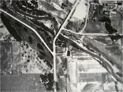
Here's 1973. You can see that the old narrow Islington Avenue bridge has been replaced by the one that exists now, and that a more-robust, but still truncated, Finch Avenue meets it directly over the river. What I found most fascinating in this view is the naked arrowhead of the bridge on the west bank, ready to one day shoulder the burden of Finch Avenue, should it ever dare to leap the river and continue west in the direction the bridge itself seems to be urging. I'm not sure when the bridge was built, but I do know that promise wasn't met for a very long time... not until about 1988.

Here's the view today, and more-or-less how things have looked for about 20 years, give or take. Finch Avenue finally crosses the Humber and heads west. Incredibly, even this was not the completion of Finch Avenue; there was still a short gap between Kipling Avenue and Albion Road, behind the Albion Centre mall, segregating most of Finch from the stretch slowly built up in the 70s and 80s to serve Humber College and the newly-constructed Highway 427 (none of which appears in any of these shots); a gap that persisted right into the 1990s. You can see that the driveway to the hospital is now completely cut off by the completion of Finch Avenue here along its ancient road allowance. The section of the driveway south of Finch is now nearly indistinguishable.

And so we come to my walk down the old driveway. I parked in the south lot of the hospital, got out, and headed down on foot. Just beyond the parking lot, the driveway is closed to vehicle traffic.


As I came to the major upper bend in the driveway, I noticed a little stone bridge and pathway on the north side, so I diverted from the driveway and had a look. It's a melancholy walk up to some of the buildings, and I can't imagine what it was ever built for. Even if one had walked to the driveway in decades past, the driveway itself didn't really lead to any amenities. It seems to serve no purpose, now or then, that I can think of.
But it was certainly photogenic.


 I returned to the crest curve of the driveway. Even in broad daylight in the late summer sun, it's a cold, oppressive place.


A little further along still, I came to the mouth of a gravely road leading off to the north and skirting the heights over the river. In the 1973 shot a little further down, you can see this trail once let some some sort of outlier building or buildings. There seems to be nothing in that vicinity now but a clearing. Nevertheless, this trail seems to receive at least some measure of maintenance, though as you may have noticed, none of the neglected street lamps in this area have been kept up.
On the side path, I found a little stone bridge, and a manhole cover dated 1960. (P.S. Looking at the photo now, I strongly suspect that's poison ivy creeping along the edge of the bridge there...)


Back on the main road, I resumed my trek down to Finch Avenue.


At the end of the driveway, cut off from Finch by a chainlink fence and a drop of 2', I was nearly run over by a teenager racing down on a bike. He narrowly missed me and turned onto a footpath on the east side. I had wondered if I would find an access to the roads, or under them, when I got there, and his speedy, confident zip into the trees was my first solid indication that that was the case. So I followed.
The chainlink fence had been widely and thoroughly pried open by pedestians. One branch of the trail seems to lead down the steep hillside to the river; the other takes one to Finch Avenue.

To remind you of what you're about to see, and how it differs from the area traditionally, here's a wider view of the 1973 shot. Emerging from the woods, I would be climbing onto the point of that big white arrowhead — only today, it carries Finch Avenue west across the field on the left side of the image.

Finch Avenue. The apartment building, which does not appear in the 1973 shot, is on Islington Avenue. Islington Avenue itself, up to sometime in the 1960s, would have been at the extreme right of this shot, at the end of the row of trees along Finch, and would have crossed its original narrow bridge just behind me over my right shoulder.

The views below have only existed for about 20 years. Before that, you'd have seen a grassy field, and cars turning either north or south when they T-junctioned at Islington.


Looking west up the "new", post-1988 stretch of Finch Avenue.


A wide-angle view of the intersection, looking east.

Manhole cover in the "new" section of Finch. Dated 1988.

A millennium plaque on the bridge. This suggests to me the bridge must have undergone some sort of work in 1999 or 2000.

I headed back down the path, and back along the abandoned (by all except myriad pedestrians and cyclists, apparently) driveway.


I found this strange, leaning tree somehow a poignant icon of the nature of the place.

MapArt's start eventually blossomed into investigations of the aerial photos at the City of Toronto Archives. What the maps merely hint at, these photos can confirm or deny, as you'll see below.
One of the intriguing things I found, but until just last weekend never really followed up on on foot, was an aspect of the gap that used to exist in Etobicoke's road grid west of the Humber. Up until quite recently, there was a substantial dearth of means to get back and forth between Albion Road in the south and Highway 7 in the north. The principal means one would have rightly expected to use, Steeles Avenue and Finch Avenue, did not cross the Humber until rather late in the region's history. Indeed, for all intents and purposes, Finch Avenue was a dead issue altogether west of the Humber, to the point that it eventually had to elbow its way though existing subdivisions to eventually make its way west into Mississauga. With the exception of a Rowntree Road — a residential street whose narrow, one-lane, wood-decked bridge still exists but has been closed to traffic for decades — there simply was no way across the Humber in this area until Steeles finally leapt the river in 1983. Finch Avenue didn't continue west of the river until 1988, which is astounding to me.
The one "cheat" that always stood out to me was a two-lane hospital driveway leading up from Islington Avenue just a little south of its T-intersection with Finch over the river itself. It always looked to me like this might have been a shortcut across the stretch that, until about 20 years ago, was unserved by a proper road. It twisted and turned, but eventually would have led drivers to Kipling Avenue, and access to the roads of Rexdale (ever the poor cousin in Etobicoke, it seems to me).
The driveway leads to a hospital that seems, given the various names it's had over the years, to be dedicated to the health — particularly the emotional health — of the children of the region. When I was in university, I had an English professor, a Czech author of some renown, who made a sly comment on this trend of political correctness. Speaking of a woman who had been consigned to 'The Home for the Desperately Poor', he remarked, "...because in those days, they didn't use fancy names; they just said it." And so, the hospital in question, on the various maps I have, has been styled first "County Branch Hospital for Sick Children", then later "Thistletown Hospital", then "The Ontario Hospital for Emotionally Disturbed Children", and finally, "Thistletown Regional Centre for Children and Adolescents". Seems the pits for political correctness was in that third example, from c. 1970 to c. 1990.
Some time ago, I went to the Archives to photograph that intersection as it appeared over the years. You can see the driveway shoot off northwesterly at an acute angle, until eventually it was cut off by the construction of Finch Avenue, and to which, strangely enough, it does not connect.
Here's how Finch and Islington met in 1950. Islington Avenue comes in at the bottom, crosses the Humber on a narrow bridge, and then heads north-northeast, where a very anemic-looking Finch Avenue meets it gasping and dies in its arms. South of the river is the driveway to the hospital, neatly lined with what look like recently-planted trees.

Here's nearly the same view in 1960 (I didn't match this particular photo with the other three, which all do line up precisely). You can see that the principal change here over ten years has been the arrival of suburbia.

Here's 1973. You can see that the old narrow Islington Avenue bridge has been replaced by the one that exists now, and that a more-robust, but still truncated, Finch Avenue meets it directly over the river. What I found most fascinating in this view is the naked arrowhead of the bridge on the west bank, ready to one day shoulder the burden of Finch Avenue, should it ever dare to leap the river and continue west in the direction the bridge itself seems to be urging. I'm not sure when the bridge was built, but I do know that promise wasn't met for a very long time... not until about 1988.

Here's the view today, and more-or-less how things have looked for about 20 years, give or take. Finch Avenue finally crosses the Humber and heads west. Incredibly, even this was not the completion of Finch Avenue; there was still a short gap between Kipling Avenue and Albion Road, behind the Albion Centre mall, segregating most of Finch from the stretch slowly built up in the 70s and 80s to serve Humber College and the newly-constructed Highway 427 (none of which appears in any of these shots); a gap that persisted right into the 1990s. You can see that the driveway to the hospital is now completely cut off by the completion of Finch Avenue here along its ancient road allowance. The section of the driveway south of Finch is now nearly indistinguishable.

And so we come to my walk down the old driveway. I parked in the south lot of the hospital, got out, and headed down on foot. Just beyond the parking lot, the driveway is closed to vehicle traffic.


As I came to the major upper bend in the driveway, I noticed a little stone bridge and pathway on the north side, so I diverted from the driveway and had a look. It's a melancholy walk up to some of the buildings, and I can't imagine what it was ever built for. Even if one had walked to the driveway in decades past, the driveway itself didn't really lead to any amenities. It seems to serve no purpose, now or then, that I can think of.
But it was certainly photogenic.


 I returned to the crest curve of the driveway. Even in broad daylight in the late summer sun, it's a cold, oppressive place.


A little further along still, I came to the mouth of a gravely road leading off to the north and skirting the heights over the river. In the 1973 shot a little further down, you can see this trail once let some some sort of outlier building or buildings. There seems to be nothing in that vicinity now but a clearing. Nevertheless, this trail seems to receive at least some measure of maintenance, though as you may have noticed, none of the neglected street lamps in this area have been kept up.
On the side path, I found a little stone bridge, and a manhole cover dated 1960. (P.S. Looking at the photo now, I strongly suspect that's poison ivy creeping along the edge of the bridge there...)


Back on the main road, I resumed my trek down to Finch Avenue.


At the end of the driveway, cut off from Finch by a chainlink fence and a drop of 2', I was nearly run over by a teenager racing down on a bike. He narrowly missed me and turned onto a footpath on the east side. I had wondered if I would find an access to the roads, or under them, when I got there, and his speedy, confident zip into the trees was my first solid indication that that was the case. So I followed.
The chainlink fence had been widely and thoroughly pried open by pedestians. One branch of the trail seems to lead down the steep hillside to the river; the other takes one to Finch Avenue.

To remind you of what you're about to see, and how it differs from the area traditionally, here's a wider view of the 1973 shot. Emerging from the woods, I would be climbing onto the point of that big white arrowhead — only today, it carries Finch Avenue west across the field on the left side of the image.

Finch Avenue. The apartment building, which does not appear in the 1973 shot, is on Islington Avenue. Islington Avenue itself, up to sometime in the 1960s, would have been at the extreme right of this shot, at the end of the row of trees along Finch, and would have crossed its original narrow bridge just behind me over my right shoulder.

The views below have only existed for about 20 years. Before that, you'd have seen a grassy field, and cars turning either north or south when they T-junctioned at Islington.


Looking west up the "new", post-1988 stretch of Finch Avenue.


A wide-angle view of the intersection, looking east.

Manhole cover in the "new" section of Finch. Dated 1988.

A millennium plaque on the bridge. This suggests to me the bridge must have undergone some sort of work in 1999 or 2000.

I headed back down the path, and back along the abandoned (by all except myriad pedestrians and cyclists, apparently) driveway.


I found this strange, leaning tree somehow a poignant icon of the nature of the place.

Subscribe to:
Posts (Atom)