
Monday, September 09, 2013

A bath on Bathurst

This is Bathurst Street in Toronto. You'll find Honest Ed's there. A street car line. Tens of thousands of cars in traffic.


But, as it turns out, this is also Bathurst Street...


Bathurst Street goes for miles and miles northward from Toronto. Eventually it becomes just another little two-lane concession road, but carries the name all the way north to Holland Marsh, at least. Recently the Toronto Star had an article about a short little chunk of the road that was closed to vehicular traffic in the 1990s (edit: specifically, April 27, 1995), and the prospect for it to be reopened, though probably by some sort of close new course. In July, P-Doug and I went out there to record the current closed course, and I went back there again yesterday to pick up the things we didn't get the first time.

When we were out there in July, it was a rainy weekend after a rainy week. So far as I know, this part of Bathurst was never paved. It's now just rutted mud, and was extremely challenging, even treacherous, when we were there. We nearly got to the north extreme where the road resumes again, but we were faced with a downward slope that we thought better of, and consigned that to another day (as it turns out, yesterday). Almost as soon as we turned back, it began to rain lightly. Then harder. Then harder. Finally it was coming down about as hard as I can ever remember being outdoors in. We were absolutely drenched by the time we got back to the car, and even then, we waited out the downpour for most of another half an hour before heading home. We were so soaked that I was astonished later on when our watches, cameras, and cell phones all still worked.

I'd gone out there expecting only the interesting closed road itself. What an unexpected delight it was to be treated to a bonus little bridge! It's like buying a little box of silver coins and finding a gold coin at the bottom. This bridge was absolutely ruined by its service over the years (my guess is it dates to the 1920s). Almost all of its railings had been knocked off, and its sides were guarded by concrete barriers lugged down and left there to do ad hoc work. It's little wonder they closed the road. Far more astonishing it was open to automobile traffic late enough that even I could have driven it in the years immediately after I got my license... though given how incredibly poor it's gotten in just the 20 years or so it's been closed, I have a hard time imagining anyone actually driving this thing by the 1990s in reality.

As I say, I was back there yesterday, mostly to shoot the view at the north end that we didn't quite get to last time, but also to get a better look at the bridge itself, this time from down in the creek bed.

It'll be interesting if they do put a new course through and reconnect Bathurst Street to itself. I'd like to see that. And photograph it happening. "Fix, if you must, this road that's dead, but spare that little bridge," he said. :)


(
Above is as far as we got in July; this is where we turned back. You can just make out the telephone poles of the existing, open stretch of Bathurst Street beyond the hill. That's where I made my way up from yesterday...


New work on Duffy's Lane

A long time ago now, a fellow road nerd put me on to Duffy's Lane on the north end of Bolton. It's a sort of work-around for one of the concession roads that only a major undertaking and several truly gigantic bridges could have permitted a straight course. As it is, it dekes around a bend of the Humber. Previously, it had a much more literal course... all right angles, and across a small bridge. The bridge, which was replaced in 1985 by the current one, was probably a single-lane pony truss bridge like others on the Humber in Bolton, but I have no way of confirming that; it's merely speculation on my part. But the old course was a nice stroll, and it gave access to the river and lot of pleasant hours down there.

The new, post-1985 course of the road put a more sensible curve in it and gave it a modern two-lane steel-and-concrete bridge. But apparently even this won't suffice. I heard a year or two ago that in the long run, an even newer and smoother road course is planned for it. A few weeks ago when P-Doug and I happened to be out there, we discovered the work is now underway. Duffy's Lane is currently blocked off in the space between the residences it has to service.

I took a few pictures last time I was there but decided to follow up and see how far they've gotten. Three weeks has made a big difference. The road course on the southwest side is now strongly in evidence, and the beginnings of the abutments for the new bridge are just being set down.


A lot of the trees and vegetation in the area have also been removed, revealing a hillside with a heavily clay-based soil. I discovered that to my detriment when I tried to get close to the pre-1985 abutments to photograph them, got stuck, and literally ruined my sandals. Lifting my feet tore the anchor braces out of the soles, leaving them completely useless. Now, I like to hike barefoot, sure... over mud, grass, soil, pine needle forest loam, riverbeds... but that's by choice. Being an obligate barefoot hiker over a quarter mile of gravel-strewn asphalt... not my first choice. Ah, the things I do for posterity. :)


Incidentally, the last time P-Doug and I were out there and made our way down to the river for a soak, I happened to find what I thought was a large shell. It turned out to be an enameled metal ashtray advertising Risk's Three Star Scotch Whisky... you can just make out the words and the graphic. Apparently the stuff was made from the 1880s till 1922 or so... which means the ashtray probably dates to sometime around WWI and is around a century old. Lately it's been serving me as a drink coaster. :)

Sneath Road bridge revisited

One of the bridges I visited this weekend was Sneath Road bridge in Bolton. It features a sweet one-lane pony truss bridge. Sneath Road was closed to traffic in, I believe, 2008, so this bridge was in action for nearly a century before its condition was deemed unsafe for vehicular traffic (and, technically, pedestrian traffic, though it's pretty clear they never stopped using it).

This is one of those rare, but increasingly common, success stories. Rather than destroy the bridge and replace it with something modern, the Town of Caledon opted to refurbish this bridge for the use of pedestrians and cyclists. It officially re-opened last winter.

I was out there three years ago with P-Doug, shooting the bridge in the event that the town changed its mind and decided to replace it. But, as you can see, it didn't, and the bridge is still there and looks like it will be for a long time yet. Pony truss bridges like this were nearly an icon of southern Ontario until the 1960s. There are a few left, and increasingly, they're being cherished and restored rather than scrapped.

Incidentally, the same little community, Bolton, has yet another one-lane pony truss bridge not too far north on the same river (the Humber), and it's still in everyday use for vehicular traffic. I meant to photograph it on the same trip, but time constraints suggested to me that it's a project for another weekend as the summer winds down.

Here are some shots comparing views of this bridge at its lowest ebb, and now its triumphant return.

Approaching the bridge in summer, 2010.

Same view in summer, 2013.

2010.


2013.

Closed to everyone, summer, 2010.

Re-opened to pedestrians again. Summer, 2013.


New safety features, 2013.

Looking south across the bridge to a closed, but paved, section of Sneath Road; summer, 2010.

Similar view: now a gravel footpath, 2013.

Northward approach to the bridge, summer, 2010.

Similar view in 2013.

2013 view showing the new decking and added side timbers.

Side view of the bridge in 2010.

Similar view in 2013. Restorative work on the underside and decking quite obvious.

Wednesday, September 04, 2013

The level crossing tour

Last week I decided to finally undertake something I've wanted to do for a while... start recording the level crossings in York Region before they eventually start disappearing. Sooner or later this has to happen, as suburban sprawl moves further north. There are already well over a million people in York Region. Two-lane country roads will, soon enough, be four- and then six-lane thoroughfares, and 5-minute hold-ups while freight trains pass will be increasingly unsustainable. Underpasses will begin to appear.

In the 1950s and 60s, James Salmon and Ted Churnside photographed a number of level crossings in the north end of Metro, back when it, too, was still countryside, but on the verge of development. To me it's astonishing to see faintly familiar scenes, which are now multi-lane roads passing under railroad bridges as old as, or older than, me; represented as little country roads, often gravel-covered dirt, with signaled crossings.

I want to do the same for people in the future, whose homes may one day crowd these now rural settings. The resources available to me for doing this outstrip what was available to Salmon and Churnside all those years ago; cumbersome rigs for shooting B&W still images. I can record video on the road; if I choose, where it's safe and appropriate, I can stop, get out, and shoot dozens of photos in colour and three dimensions. So I decided to head out last weekend and get it done.

The route I took zigzags north-northeast across York and into Durham, hitting most of the major crossings of the CN line. A handful of them are already served with underpasses, but most aren't. It was my intention setting out to stop and photograph each one of them, but as time passed... time passed. I realized taking 10-15 minutes at every crossing would mean the whole thing would take six or seven hours, rather than the two or three I really wanted to put into it. Besides, I'd wind up with 500 photos of very much the same scene, with minor variations, over and over. There was also the consideration that some of these roads already carry a fair amount of traffic, making just pulling over and wandering around a little risky; also, some of them simply didn't have convenient places to stop. So in the end I decided to just photograph a few... ones that really struck me, and where it made sense to stop. There were three, which I think is a good representation.


St. John's Sideroad

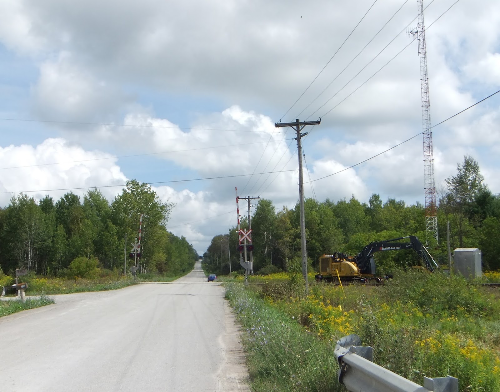
This was a pretty spot on a road with not much traffic on it. While I was there, I thought I heard a train whistle in the distance, so I decided to stick around for a couple of minutes. Sure enough, down the track I saw the approaching lights. I recorded a freight passing by at the crossing... it took about four minutes for it to pass. Don't worry; the video's been abridged; shortened to about two minutes.

Even at my age, and knowing one is standing safely to the side, I have to say, watching  a train bear down on one is still impressive and a matter of mastering a deep, ancient urge to dash away. :)


McCowan Road

McCowan's actually a fairly substantial north-south street further south of here. One thing that might limit its growth is that there's a short gap in it a few miles south of this crossing, with a village at the foot of the hill where it resumes... though they might eventually bypass it, I suppose. It's also in, or in the vicinity of, the Oak Ridges Moraine, which could also mean it won't be developed or change considerably. But, you never know; so I decided to stop and take a few shots.


Zephyr Road

This is just a bit over the border into Durham Region, where I was getting to the end of trip, and nearly the turn-around point. It was a dirt road, with a little bridge over a slow creek next to the crossing. I had to stop and get that. It's like those shots of Steeles Avenue in gravel I was talking about... it'll be hard to believe, one day.


I turned around after I got to Ravenshoe Road, which is both the upper border of Durham and as far as I'd planned to go anyway. Below is a compilation of the views of the level crossings I travelled over. Each is a pair: first either heading north or east, as the road might be; the second being the same crossing on the return trip, heading south or west again. The whole thing runs about 15 minutes, so I'm not expecting it's just everyone's cup of tea. But if you like that sort of thing, and  you have fun trying to imagine how it's going to seem to someone 50 years from now, have a look. :) (Note: most of the music, which is all ambient, in-car, is by Junkhouse, with a few by Symphony of Science.)


As an aside... I think the biggest kick I got out of the whole thing was when I came over a rise and saw the view of the dogleg intersection of Queensville Sideroad with York Durham Line. It immediately evoked the image of the old intersection of Finch and Woodbine Avenues in North York... an intersection that ceased to exist about 35 years ago. Finch was widened, given to new course eastward from Woodbine to meet another section of itself at Victoria Park Avenue; and Woodbine Avenue in North York died, as such, to become the 404. I always wondered it would have been like to have driven the view seen below... and now, in a way, I feel like I have. The bottom view below is very much like what approaching Woodbine eastbound on Finch prior to the mid-70s would have looked like.


Tuesday, September 03, 2013

Wednesday, August 28, 2013

Latest assingments

Well, in lieu of having a life just at the moment, I've been catching up on some of the places I wanted to visit and record for posterity. Thought I'd share some of the recent video for the amusement of anyone for whom that kindles a spark. :)

The first three here are of the old Bayview Avenue bridge near Bayview's one-time intersection with Lawrence Avenue down in the valley. I'm not sure when this bridge was built; probably at the end of the 19th century; but it was superseded by the adjacent and much more impressive current Bayview Avenue bridge just to the west, which was built in 1929 (and then twin-spanned in the early 60s). Presumably 1929 was the year this bridge went off the road grid... though every so often, restorative work to its successor breathes new life and purpose into this old bridge, and that's what's going on right now. So all the crap and weed growth and erosion ruts have been, at least for the moment, cleared away, and I wanted to get some shots of this bridge more like how it would have looked in its glory days a century ago... and here's the video.


Now, below is the old Major Mackenzie Drive bridge (technically the Humber Bridge Trail bridge now). I'm not sure just when they diverted Major Mack down the big sweep it now makes to the south, but aerial photos show this was still the route in the mid-50s, and probably was till the late 1960s. You'll see it's a dead end now once you cross the bridge, but the road used to creep up the hill, make a sharp turn, and come up at the top to recover its straight route. I tried hiking that yesterday and only made it to the sharp turn... after that, it's just too overgrown and eroded... just a V-shaped, fallen-tree-strewn remnant of whatever road it once was. But, the bridge is still there, still serves a home on the far side of the Humber, and the plans are to refurbish it soon.


Below is the Wiley bow arch bridge on Gorewood Drive, or what used to be Gorewood Drive. It's now closed to traffic but the bridge still serves as a pedestrian crossing of the Humber; this is now a conservation area. The bridge is, to my eye, in really good shape; only a few places are really in need of restoration efforts. Strange that this bridge has been out of service for decades, while the much more decayed old Major Mack bridge is still in use.


Finally, just for the hell of it, here's a timelapse video I made just before I moved a couple of years ago. I'm particularly fond of this because it's not just a video I sped up. It's actually several thousand photographs taken automatically by my Rebel XT every second or two. The blur effects are thanks to my using a neutral density filter to enable me to prolong the exposures to roughly half a second without blowing out the photos. So, you dump them all together in Premiere, add a little mood music, and voila... a high-speed trip through the northwest end of town. :)


Thursday, August 22, 2013

A snowball's chance


One more reason I'm glad I bought a dash cam last January. :)

Friday, August 09, 2013

Random reflections on the bridges

I thought I'd jot down a few of my impressions while they're still in my mind...

When I was younger, I used to have these dreams where there were whole rows of tornadoes, one after another. I never thought that was actually possible till I saw a video a guy shot in the Midwest in the 90s of six relatively placid twisters all lined up in a lazy row along the horizon.

Same kind of thing with the bridges in Wellington, Waterloo, and Dufferin. I've seen a mere handful of bow arch bridges in my time. They're fairly rare now in Peel, Toronto, and York. The only ones that leap to mind are the Pottery Road bow arch that's still in service carrying southbound traffic across the Don River, and the Etobicoke Creek Middle Road bridge on the Toronto-Mississagua border that's been closed since the late 70s (second one of its kind in North America, and now the oldest surviving one: 1909). There are probably others but, again, they're scarce enough that they don't leap to mind.

Bow arch bridges further west, though, seem to have been all the rage a century ago, in the same way that pony truss bridges were once everywhere in York County, hereabouts. I think for every one we saw, we missed another, and probably at least as many again have vanished down the memory hole in the past 30 years. But I saw over a half a dozen out there in the space of a few hours, and all but one of them still in service. At least for now. We saw three or four places with boring recent bridges featuring plaques that proudly, even gratuitously, boasted of bow arches they'd replaced. My impression is that most of these bridges will disappear in the next generation. Roads will be paved and widened and "while you're at it,..." will probably doom several of them. With the Stone Road bridge set aside as their avatar, there's probably not much that's going to save the others.

With regard to the others: the Bailey bridge on Niska Road is in serious study for replacement. It was put up in 1974 as a temporary measure, and it's attracting far more use than was intended. People are using it to avoid the traffic on Stone Road to the north, and despite its low posted speed, people are just flying over it. As a one lane bridge, it poses a serious safety issue, and it's been the site of several fatalities over the years. So I'm glad we recorded it when we did because it seems to me the responsible thing to do, no matter what the neighbours say, is to either replace it with a wider span, or close it altogether.

Ditto the Perth Street wooden bridge. I don't know how many actual wooden bridges are still in use in southern Ontario, but there can't be many. You can see from the photos that this one's rough shape, and if it makes it to the 2020s, I'll be surprised. So, again, I'm glad we took the time to record it.

But for all that I think the most astonishing bridge it was my privilege to meet last weekend was the Buggy Lane bridge. It's the first time I can remember being on a genuine one-lane road that was still open and in good repair in Ontario, and for miles at that. And I mean a REAL one-laner... no one and a half lanes and squeezing past each other. Room for one vehicle, period. We kept encountering signs we weren't going to get to the bridge. No exit signs. Dead end signs. But no barriers, no signs telling us not to trespass as though the thing had been given over to private property... no, we pressed on, puzzled, to see what we'd see, and eventually came to the bridge, crossed it, and met an intersection with stop signs and everything. So what were all the tricky signs about? Still, the wooden decking of that bridge was the shakiest of all and again, I'll be surprised if people are still using it in a decade.