


When the original photo was taken in 1966 (and, by the way, folks at the city archives: you're displaying it backwards; it appears corrected below), the bridge was on what was Peel County's Eighth Line East; as far as I know, it was still so-called at the time. Today, south of Steeles, it's renamed for Finch Avenue, which grew west out of Metro Toronto in the early 80s to turn north and take over the route; up to the bridge it's now called Gorewood Road (though it's closed to traffic about a quarter mile north of the 407); north of the bridge it's Claireville Conservation Road (poetic, that, huh?), and then, finally, north of Hwy 7, it's McVean Drive. Not bad for a little country road that's got so little traffic.
Anyway, I'd been to the bridge before. GoogleMaps is a boon to people looking for sad old closed roads and lost bridges. This one, I've discovered recently, was built in 1924, was referred to (for reasons that current elude me) as "Wiley Bowstring Bridge", and served into the 1960s when it was (I suppose) closed as the regional authority turned the place into conservation land. I was at the bridge a few summers ago and wandered a bit of the treed plain beyond. Discovering the 1966 photo was a jaw-dropper; there are nearly no trees immediately near the bridge or beyond it 1966. By the early years of this century, they had really closed in around it, as you'll see.


The bridge can be seen from the crest of the hill above it. But the 1966 shot was taken from beside the road (evident from the fact you can see the outside of the bridge), and from above (the top of the bridge is below the horizon line). As I approached the bridge, I began to despair of duplicating the shot. As with many others I've tried, the intervening years have filled the original photographer's perch with trees, brush, or sometimes new construction. In this case, it was trees. To match the shot, I had to leave the road and climb a slippery, grassy slope. I'm usually in sandals in summer and I learned long ago the best way to deal with this is to take them off. Even so, to match the shot, I had to stand on a slope that constantly threatened to send me sliding down into a ditch twenty feet below. I had to pick my way through a lot of underbrush but I finally reached a spot that approximated, but didn't exactly match, that of my predecessor... I was about a foot too low and a yard too far to the right, thanks to a tree that had grown up in the meantime and refused to make way for me even for a few seconds. Still, not a bad match, though I say so myself, especially given that I had no visual cues from the west side of the bridge to work with.


Getting down was about as tricky as getting up. At one point, I stepped onto something rather sharp that penetrated the sole of my right foot just back of the fourth and fifth toes. I made a face and gave a grunt; I've learned to manage this kind of thing (I remember well stepping on a thorn once on the Humber Valley Heritage Trail just as I was lining up a shot of a deer and stifling the yelp... still missed the shot). I put my sandals back on as I reached the gravel road again and I could feel the blood making my foot stick to the sandal as I wandered over the bridge a couple of minutes later. Ah, but it's like jellyfish stings if you live by the sea... it's part of the price of enjoying summer and you get used to it. Didn't bother me more than a minute or two.


Coming back up the hill from the bridge, I took a shot from the lip all the way down the road. Between a quarter and a half a mile away, you can see first the bridge of the 407 over Gorewood Road, and beyond that, the intersection of Finch and Steeles Avenues.

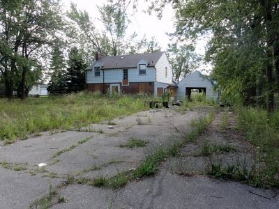
While I was driving up Gorewood, I noticed that all the houses—every single one of them—seemed to be abandoned and boarded up. People were quite comfortably living there the last time I was at the bridge a few years ago. I don't have any idea why they would have sold out as a block. House listings suggest they're being sold as houses... but that doesn't explain why everyone left at the same time. That they seem to be being sold under power of sale suggests to me that maybe they were bought up en masse by someone with a plan for the whole strip (the houses are all on the west side; there are none now on the east, if there ever were), bought them all up, and then the project fell through, so the investors are left with about a dozen homes, priced in the $500K-600K range. Anyway, it occurred to me that they just might be on the way to consignment to history, so I thought I'd walk the length of the street and record what they looked like from the street. This time next year, these lots just might be scrub land again.


6 comments:
Bowstring bridges are very cool and somewhat rare. So I'm really pleased to see this one, especially because it seems to be in good shape. For examples of bowstring bridges in the US, type "bowstring" in the search box here: http://bridgehunter.com/search/.
Also, the photos of the boarded-up houses reminded me of this outstanding blog: http://56housesleft.wordpress.com/. It is not updated anymore but it tells the story of a neighborhood's destruction -- very interesting stuff.
The real irony here is that there are still quite a few bowstring bridges in and around Toronto, and a few are still in use (the one at Pottery Road springs to mind, twinned with a boring box girder bridge since 1977 to make traffic two-way); it's the pony trusses we've been losing. The other three bowstrings I can think of (assuming I'm not being too general with the term) are this one here, Middle Road Bridge, and the old Don Mills Road Bridge... these three are now closed to vehicular traffic, though, where Pottery Road is still in use every day. Ah, another one I know is still open is on Humber Bridge Trail, which used to be part of Major MacKenzie Drive (17th Avenue at the time, I think), but that bridge actually only serves one resident at the moment.
I remember seeing that blog before! It must have been on your recommendation at some point a couple of years ago. :)
Humber Bridge Trail, still open to cars: http://www.flickr.com/photos/loneprimate/2115761484/
Pottery Road, still open to cars: http://www.flickr.com/photos/loneprimate/4242996886/
Old Don Mills Road (carries cars to a parking lot only): http://www.flickr.com/photos/loneprimate/117023535/
Milddle Road Bridge: http://www.flickr.com/photos/loneprimate/4654924062/
Someone in authority in Toronto sure must have loved concrete bowstring arches!
Well, I've been told lately there was an architect named Frank Barber, active in the early part of the 20th Century, who was an advocate of the new concrete bowstrings and wound up in a position to start building them. I'm informed that Middle Road Bridge, dating from 1909 (closed in 1972, I think) was one of his: "the first reinforced concrete parabolic bowstring truss bridge constructed in Canada", only the second of its kind in North America and the oldest now that the first, somewhere in Tennessee, was demolished at some point. Apparently Frank Barber was the designer of some of the area's most notable bridges (not all of them bowstrings), many of which are still in service today.
From what I've read, bowstring bridges were actually quite distinctive of Ontario in particular: http://bobhulley.blogspot.com/2007_09_01_archive.html
Oh, yes! And how could I forget the McEwen Bridge over the Humber on Kirby Road, my own dear "discovery" of a few summers ago? :)
http://www.flickr.com/photos/loneprimate/2420199890/
It wasn't the age of this bridge that closed the route, but a landslide that bisected Kirby Road above the Humber sometime in the 90s. There's some talk in York Region of refurbishing the bridge, much as Toronto and Mississauga did with their shared Middle Road Bridge in the 1980s.
Post a Comment