Jim over at Down the Road, in a very kind and gentle (and probably inadvertent) way, made me kind of get off my butt yesterday and put my bridge where my mouth is. :)
I found out about this bridge about ten years ago when someone casually mentioned it on their photoblog and posted a picture of the abutment you see below in a recent posting. I did research and found aerial photos of it, crossing the Don as part of a rather scrotum-like course that once carried Lawrence Avenue East into the Don Valley and across the East Don. It's only been in the last couple of years that I've actually come across photos of that bridge from a human perspective. I put a few things together for Jim's benefit, but it occurs to me now that, now that I have them gathered at last, I ought to do what I've been meaning to for a while and post them. Someone out there might really love to see this.
Here's what the area looked like in 1947.
For context, here are increasingly wide views of the area today... the last corresponding with the 1947 view above, more or less.
Here's a shot of the bridge, looking southward, I think, dating from probably the 1940s.
Here are a couple of shots taken by James Salmon in the 1950s. The bridge was closed at the time, apparently. I suspect this had something to do with Hurricane Hazel. I suspect the bridge was open to traffic again prior to its removal circa 1963, when the current six-lane course of Lawrence was opened about a hundred yards to the north, and the Don Valley Parkway was constructed out of the south up the road allowance of Woodbine Avenue. There never was a corner of Lawrence and Woodbine, but technically there kind of was, if you see what I mean. These views look west.
Showing posts with label Don Valley Parkway. Show all posts
Friday, April 01, 2011
Wednesday, October 07, 2009
Retrospectives: Finch Avenue and Woodbine Avenue
One of the places in the city I've found interesting for several years now is what used to be Woodbine Avenue... the stretch between Lawrence Avenue and Steeles Avenue in particular. Much of it wasn't around very long, or at all, really. In the north end of the city, it has the misfortune — or colossal good fortune, depending on how you look at it — to have been in line with the course of the Don Valley Parkway.
The DVP was built in the early 1960s. Originally, it went as far north as Sheppard Avenue, where it petered out to become Woodbine Avenue immediately to the east of Fairview Mall. It had assumed the course of Woodbine south of that point, though for at least some of that stretch, there never actually had been a road, just the allowance. I don't believe there was ever an intersection of Woodbine and Lawrence, for example. The Don River's twists and turns simply made that unfeasible for people much before about 1950.
For many years, there was talk of extending the DVP northward, at least as far as Steeles Avenue, where Metropolitan Toronto ended. Eventually, the province took over the idea, and assumed the DVP from north of the 401, recreating it as the first stump of the 404. By 1976, the expansion was underway, and Highway 404 was well and truly born as it ate up Woodbine Avenue south of Steeles. At that point, it deked to the west, leaving Woodbine Avenue extant in York Region, where it is today a major thoroughfare. But in Toronto, that section of Woodbine is gone.
I'm used to roads being paralleled by, or bisected by, or underpassed by superhighways, but the idea of one taking over the course of a regular road is a strange idea to me. What made it possible is that so little actually existed on Woodbine Avenue inside Metro. For me, the most interesting dislocation caused by this was the intersection of Finch Avenue and Woodbine, which, of course, no longer exists as such (the relatively newly created intersection of Woodbine and Van Horne Avenue also ceased to exist at the time, though in a different fashion: for about ten years, the two streets met at a simple at-grade intersection; now Van Horne is carried by a bridge over the trench of the 404 with no interchange between them at all). (View below, Woodbine and Van Horne, 1970.)
Finch Avenue, for its part, has been a broken, fractured collection of several discontinuous roads across the north end of town, united in little but name until quite recently. Where it met with Woodbine was no exception. It formed a dogleg of about 30 yards. Just a little east, where it met Victoria Park Avenue, the separation between the two discontinuous parts of "Finch Avenue" was nearly half a mile! Below is a modern aerial view of the area. The red lines represent the broken course of Finch Avenue back in 1965. The yellow line was the course of Woodbine Avenue then, and Hwy 404 today. The blue line is Victoria Park Avenue. The two teal dots represent the approximate locations from which the 1965 photographs further below were taken.
This began to change in the 1960s, and was completed with Finch Avenue's own completion in the far west end in the 1990s. As for the dogleg at Woodbine, it was eliminated in 1976-1977 with the creation of Hwy 404 (you can see the new "swoop" of Finch Avenue in the modern aerial view above). A comparison of the 1965 dogleg intersection and the modern interchange:
The photos below, from the City of Toronto Archives' website, show the intersection of Finch and Woodbine in 1965, probably taken by someone who knew the view wouldn't survive the decade by much. The first photo was taken on Finch, facing east to the intersection with Woodbine, from the position of the lower teal dot in the aerial view. To the left in the picture (that is, north), you can see the disconnected continuation of Finch eastward towards Victoria Park Avenue, out of sight beyond the rise. Much of that stretch of Finch still exists today as a couple of residential streets (Pawnee Avenue and part of Micmac Crescent, to be specific) and a path through a park. It would be impossible to see this view today, because this is where Finch crests Highway 404 over a bridge in the middle of their interchange. Finch then veers away to the south, away from the old dogleg, to meet up with the other stretch of Finch at Victoria Park. Note the trees across Woodbine, marking the little lost homestead visible in the 1965 view in the comparison view above.
A similar view today.
This photo was taken on Woodbine Avenue to the north of both parts of Finch, facing south towards the 401 out of sight off in the distance, from the position of the upper teal dot in the aerial view. Today, the view would be southbound down the 404; back then, it was a two-lane road taking cars down to the DVP, and leading them north from it.
A similar view today (taken from approximately the location of the truck and the car in the above photo).
Another view of the intersection... this one from a book about Toronto dating from the late 1970s, and showing the view from the hilltop north of the homestead, facing west towards where Finch now meets Don Mills Road beyond the crest of the hill.


It goes without saying, I suppose, that virtually nothing in these shots still exists. The land in these views is now under either the highway, or the suburbs that were already being built out of sight up the rise on the right in the second photo. For me, it's one of the more dramatically-changed streetscapes in the city, which is one of the reasons I've found it so fascinating.
Parting shot: this is the location of the little homestead on the east side of Woodbine, today.


Parting shot: this is the location of the little homestead on the east side of Woodbine, today.

Labels:
404,
Don Valley Parkway,
Finch Avenue,
North York,
Toronto,
Woodbine Avenue
Monday, May 15, 2006
A little photography on the weekend
On Friday, I bought a Canon Powershot S80... several reasons... it's nearly the P&S equivalent of my Rebel XT (except it literally fits in my pocket), it does AEB spreads, it's 8-megapixal with good macro and unusually wide angle facilities, and I was told it's being discontinued. It's hard to find in Toronto; seems to sell out the minute it hits a store. All good indicators.
And I think it is a heck of a good camera. I've had a lot of fun with it already.
This past weekend the Don Valley Parkway was closed for maintenance. I suggested to P-Doug this was a once-in-dog's-age opportunity to shoot the empty highway, so down we went.

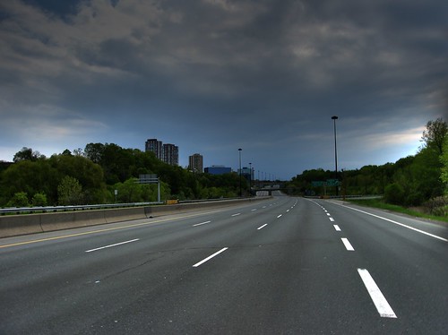
High dynamic range image (created from a three-photo auto-exposure bracketing spread) of the DVP, looking southward in the southbound lanes south of Lawrence Avenue. This was taken using the S80.

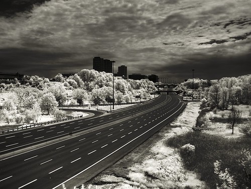
High dynamic range, infrared image taken from Lawrence Avenue, looking south (somewhere in this shot is the spot I was standing in the one above). This was taken using my infrared-converted Canon G1.

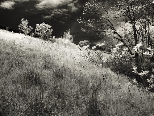
Climbing up to the onramp/offramp at Lawrence (this shot was taken just before the one above). Again, this is an HDR IR shot taken with my Canon G1.

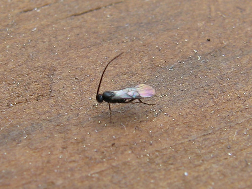
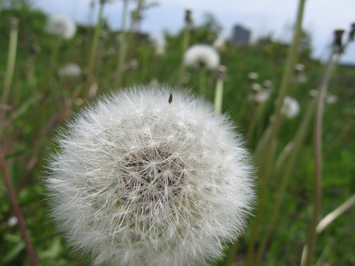
A crop of a macro shot of a tiny wasp, taken with the S80. The little white dots are salt crystals. This wasp was perhaps 1/16" long, and the lens was about an inch from it when I took the shot.

Another macro shot with the S80.

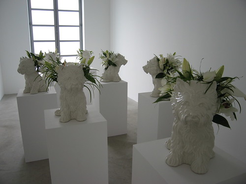
On Saturday, P-Doug and I took in an art gallery down on King Street. This piece is called "Puppy", and it's by Jeff Koons.
And I think it is a heck of a good camera. I've had a lot of fun with it already.
This past weekend the Don Valley Parkway was closed for maintenance. I suggested to P-Doug this was a once-in-dog's-age opportunity to shoot the empty highway, so down we went.

High dynamic range image (created from a three-photo auto-exposure bracketing spread) of the DVP, looking southward in the southbound lanes south of Lawrence Avenue. This was taken using the S80.

High dynamic range, infrared image taken from Lawrence Avenue, looking south (somewhere in this shot is the spot I was standing in the one above). This was taken using my infrared-converted Canon G1.

Climbing up to the onramp/offramp at Lawrence (this shot was taken just before the one above). Again, this is an HDR IR shot taken with my Canon G1.

A crop of a macro shot of a tiny wasp, taken with the S80. The little white dots are salt crystals. This wasp was perhaps 1/16" long, and the lens was about an inch from it when I took the shot.

Another macro shot with the S80.

On Saturday, P-Doug and I took in an art gallery down on King Street. This piece is called "Puppy", and it's by Jeff Koons.
Labels:
Canon S80,
Don Valley Parkway,
HDR,
infrared,
macro
Saturday, February 25, 2006
Winter finds a bend in the Don

Winter finds a bend in the Don
Originally uploaded by Lone Primate.
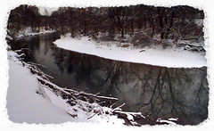
This is one of those "deliberately bad" Kodak DC50 shots I've been promising. At its lowest quality setting, this eight-year-old early model digital produces images that look just a little like watercolour paintings. This particular shot is of a bend in the Don River just a little south of the big bridge that carries the Don Valley Parkway over it, in Ernest Thompson Seton Park, and was assembled from four images by AutoStitch.
Subscribe to:
Posts (Atom)