
Map of Cummer Ave. and Old Cummer Ave., MapArt (note: map dates from 1999; Old Cummer Ave. is no longer open to traffic as indicated here)
I find myself constantly surprised by just how quickly Nature recovers the things we presume to take from her. Surprised, too, by just how much there is to discover in the least likely places in the city. Case in point, the unfortunately named Cummer Avenue in central north Toronto.
I knew there was a Cummer Avenue; I've driven on it. I pass it often on Leslie Street. But I hadn't been aware of its older course.
After five years of living here, I finally decided to investigate the East Don Parklands just northwest of here last weekend. A footpath along the east side of the river leads you from Finch Avenue northward until you can cross the river at a small bridge, just wide enough for one car lane. I have to admit to you, I was somehow completely blinded to the significance of that when I saw the bridge. It just did not occur to me it had ever been part of the road system, even though it clearly did not match the other bridges in the park. It wasn't till I got home and looked on the map to try to see how far I'd gone that I realized the bridge had once carried Cummer Avenue.
Today Cummer Avenue is an unusually busy residential street. Since it crosses a large portion of the north end of town in a fairly straight line, it's used as an alternate to Finch Avenue to the south and Steeles Avenue to the north. It's really only had this facility since about 1968, however, when its course was changed thanks to two larger bridges having been built; one to carry it over the East Don and one overpassing it at what would have otherwise been a level crossing with the CNR. Before that, it was a quieter residential road running between Yonge Street and Leslie Street (as, actually, it still does). It had a certain importance because it bridged the East Don River. But like many such roads in their countryside youth, it didn't boldly cross the river where it encountered it, creeping instead down into the valley to find a narrow (read: cheap) place to bridge the gap. Unlike most, it did actually carry on straight from there, completing its journey to Leslie. This is reading it left to right (west to east), of course.
This photo (below) shows the road in 1953. It enters at the top left along the route it still follows today, and then suddenly heads south, curving down into the valley. You can make out the bridge at the centre left by the shadow it casts into the riverbed. From the bridge, you can see the road carries on straight eastward till it ends at Leslie Street, the north-south line at the right extreme of the shot. What's interesting to me is that there are houses on the stretch of Old Cummer that heads down into the valley on the west side. There are none there today and not a trace of them remains. I walked that path a few days ago and there was nothing there that ever got me thinking anyone might have lived there. Consider this: most of what you can see on the west side of this picture is a flood plain. 1953 was the year before Hurricane Hazel hit Toronto. I'm surprised to see these homes (especially the ones close to the bridge) still standing in later photos. Hurricane Hazel killed hundreds of people living in Toronto-area flood plains in October, 1954; it's the reason why we still have our river valleys in town — no one's been allowed to build there for fifty years.
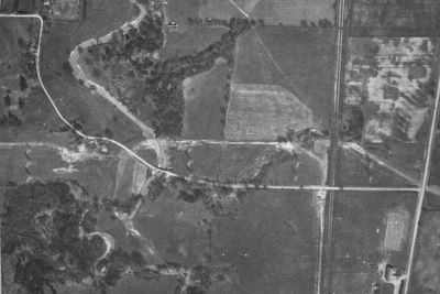
Cummer Avenue crossing the East Don River valley to Leslie Street, 1953 — City of Toronto Archives, 1953, plate 20, detail
Here (below) is a similar view from sixteen years later, in 1969. Cummer Avenue now crosses a bridge where it meets the river, and heads off to the northeast. You can see where the railroad overpass and the new stretch of Cummer Avenue were under construction at the top of the picture. Again, the north-south street at centre-right is Leslie Street. You can see that the homes in the valley on Old Cummer Avenue are still there. The road is well-defined and in good shape, and obviously stil in use; notice, in fact, it's been extended across Leslie to some sort of facility at the bottom right. I'd like you to notice, too, how open the area opposite the homes on Old Cummer is, between the road and the river. There seem to be almost no trees, and no brush at all there. I'm almost sure these people could have looked out their living room windows and seen the river, maybe two hundred yards away. You might notice a curiously open, wide expanse that runs across the picture at the bottom, in which the bridge is found. This a hydro corridor; three high tension lines cross the city at this point. You can see the towers (or at least their shadows) in all three aerial shots, but here it's first clearly defined by the residential build-up crowding it above and below.

Construction of new track for Cummer Avenue, relegation of old route to Old Cummer Avenue — City of Toronto Archives, 1969, plate 247, detail
Finally, here's what the area looked like in 1985, about a year after Metro decided to turn the area into parkland (note: this view is a tighter shot and does not show Leslie; the north-south street at the right is Pineway Blvd.). East of the bridge (if not west of it), the road is clearly closed, and you can see the beginning of the modern paved footpath heading off due south from the east end of the bridge. There still seems to be one home up at the top at the old turn, judging from what looks to be a driveway with cars in it, but the other homes between it and the bridge are gone. Today, even that home is long gone, vanished without a trace — at least to this untrained eye. Glancing back down towards the turn eastward toward the bridge again; if you look carefully, you might make out a triangular patch in the road with a little streamer of a footpath or driveway wandering away from it to the southwest where one of the houses stood... Make a note of that, and hold that thought for a few moments.

Closure of Old Cummer Avenue to traffic and demolition of its homes — City of Toronto Archives, 1985, plate 52Q, detail
Something I've noticed as I look at the aerial shots I'd like to remark on before moving along is the way the river changes course over time. If you look at the top left of the 1953 shot, you can see the river hugs the treeline and makes a wide curve. There's a farm at the turn in Cummer Avenue and you can see the shadow at the right side of it that probably marks the depression of an abandoned course of the river. In the 1969 and 1985 shots, the threeline is isolated and the river is back in the ancient course. Was this the river's choice, or did human beings move the river back to the old channel for the convenience of the road bridge built in 1968? I have a similar shot taken in 1968 just prior to the beginning of construction; the river follows the 1953 course. Sometime between the 1968 and 1969 overflights, the city forced the river down the more direct channel, it seems. Well, that settled, on to the modern era, ground-level...
A buddy of mine who works mornings joined me for an afternoon hike up the old road allowance (another was invited, but begged off for typical reasons and threatened us with "a 60% chance of rain"... this summer has been famous for promised rains that never came; I was not concerned, and as events turned out, my forecast was in fact the correct one, in spades). Today, a paved footpath (shown as a dotted line on the map) hugs the river course, but that's not all that interesting and there's nothing there to compare then-and-now. So once we crossed the bridge, we headed up what was once Cummer Avenue, later Old Cummer Avenue, and now just a narrow footpath itself.
Heading west from Pineway Blvd., you first glimpse the bridge at the lip of flood plain. This photo doesn't really do it justice; it's a rather steep drop. To give you some idea, notice that our horizon line runs pretty much along the tops of the trees beside the bridge. Standing here, you are about that much higher than the bridge. You can also see the power lines being carried across the valley. The solitary tower standing just right of centre is about fifty yards from the bridge, and stands approximately where one of the homes once stood. It seems to be more recent than the other towers, as I can't find evidence of it in earlier aerial photographs.
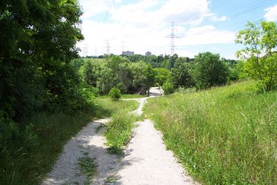
Looking west along Old Cummer Avenue road allowance to the bridge over the East Don River.
I've been to the bridge four times now but never under it until yesterday. What can I say, I'm nosy, and I've also found that some of the funniest and pithiest graffiti is to be found underneath bridges. I think it has something to do with the solitude. If you're going to deface public property to make a statement, it helps if you're sheltered from view, I guess. Graffiti on more accessible places tends to be more slap-dash, mostly tagging and other forms of territorial pissing. But underneath bridges, you'll often find the most impressive murals, some with fairly heavy and profound things to say. The words of the prophets are written on the subway walls and tenement halls, and whispered in the sounds of silence... Not this particular time, I'm afraid; the local spraypaint-wielding wags are as disappointingly uninspired below the bridge as upon it.
But to give you some idea, here's what the bridge looks like from below. I took these shots standing in the river, just south of the bridge. It's an elegant structure for something so utilitarian; at a guess, I'd say it dates from the 50s. It's hard to tell if this is the same bridge seen in the 1953 shot. It might, I suppose, be slightly older. There's no way to tell. If there was a date stamped anywhere on the bridge, my buddy and I couldn't find it. With regard to graffiti, though; the west side of the bridge (the darker shot of the two) bears, just legibly, the word FUCT... perhaps a Shawian attempt at restructuring the spelling of the English language. That seems to be as high as the artists who use this bridge as their canvas are prepared to aim.

Under the bridge, west end.
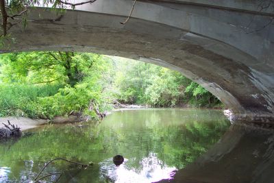
Under the bridge, east end.
Remember the triangular patch with the path I mentioned in the 1985 shot? Well, below is what that looks like today. This view is fifty or so yards west of the bridge and faces north, looking toward the river. The pathway you can see forming a "T" with this one is, in fact, the old road allowance. The path I was standing on to take the shot was likely once someone's driveway. The bush on the the far side of the road is, as you can tell, relatively young. There's little doubt in my mind that people living here in, say, 1960 or 1970 looking out their window from this vantage point would have had a relatively unobstructed view of the river, which is at the foot of the darker trees in the distance.
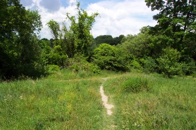
Current view from the approximate location of one of the homes at the eastward bend of Old Cummer Avenue, west of the bridge.
Below is a shot looking out across the flood plain toward the river, taken from the road. It's impossible for me to say with any accuracy where exactly I was on the road, and given that there really are no landmarks constant between even 1985 and 2005 in this view, it wouldn't make much difference if I could. Suffice it to say, I hope, that this was taken in the span between the arms of the big C-shaped clump of trees at the centre-left of the 1985 shot (um, I think). But this shot is at the heart of what I'm getting at in all this. Look how overgrown the place has become in only a generation since it was abandoned by human habitation and frequent passage. If no one told you that the photographer was standing on what had been only a little earlier a well-travelled suburban road and with his back to what was then a line of homes, you might suppose the shot was taken in a glade in the middle of a northern forest. But this shot was taken standing on a closed road in the heart of a metropolitan area of five million people. I wonder what I would have seen standing on this spot twenty years ago, or fifty. A hundred years ago, though, it probably looked just like this.
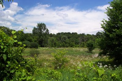
The flood plain, July, 2005.
This picture (below) is the rise to the old turn. In other words, the approach to Cummer Avenue as it stands today. This is probably under a minute's walk from a notable road where hundreds, maybe thousands of people pass by every day in cars, on bikes, and on foot. There are dozens of homes only twenty or thirty yards away on the left, and more just to the north, ahead. What you're looking at now was, around the time you were born or not long before, a cleared, paved roadway about twenty yards wide, with homes on the the west side of it (you can, in fact, see the broken pavement running in chunks up the middle of the eroded path). But could you imagine all that from this shot? That's how much this place has changed in just the little amount of time since we abandoned it; from a two lane road with homes to a footpath where you have to occasionally dodge tree branches. It makes me wonder what would survive our civilization after a thousand years, or a million. Would there be any evidence we were ever here? Anything at all?
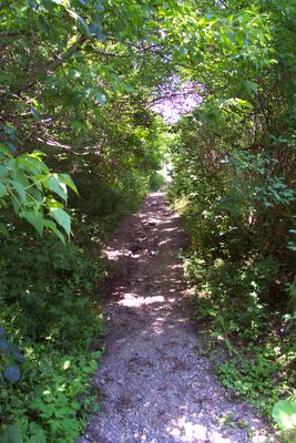
The rise to the current course of Cummer Avenue.
After we reached Cummer Avenue, we decided to keep going north for a while. We crossed the road and picked up the official path on the other side of the 'new' four-lane bridge. Not far north of there is another footbridge that crosses the river to the east side. But just before you cross, there's an unofficial path leading off into the woods, that follows the west side of the river. We elected to take that path. It's just a natural path; overgrown and unpaved, marked only by the passage of people, and even then, didn't seem very frequently travelled. We came to a steep, slippery dip that crossed a drainage ditch; it was there I took off my sandals (on inclines, they're much more of a hazard than a help), and ended up keeping them off for the rest of the trip till we got back across Old Cummer bridge and had to walk back up gravel path to Pineway Blvd. I like to walk barefoot and in natural settings I need little prompting or excuse.
The journey took us about fifteen minutes north along the river, probably about half way to Steeles Avenue. We eventually heard something like a waterfall, and my friend discovered what apprears to be an aeration dam. I know that the conservation authority has been encouraging the re-establishment of fish in this part of the river, and I imagine this was built, at least in part, to facilitate that. Curiously, the drop also features four or five abutments. I know the official path runs along the river just the other side of this point. I can't help wondering if they plan to eventually build another bridge here, and maybe widen the path we were on.
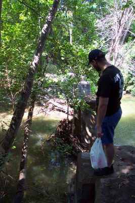
Aeration dam on the East Don River, north of Cummer Avenue.
It was more or less at this point that we decided to head back. Pausing for about half an hour on the bridge of the official pathway, we eventually took the open path (rather than the overgrown track of Old Cummer we'd used on the way up) to return to the Old Cummer bridge. The pavement was hot and rough and provided me with an interesting textural contrast to the clammy, smooth forest path. The trip back, as you might expect, was shorter and brisker.
There's a lot in this park that intrigues me and bears further investigation, both in person and combing the aerial shots to be found at the City Archives. Best of all, it's all within walking distance, unlike nearly all the other similar places I've explored over the years. I'm looking forward to getting to know the park better. I only wish I hadn't waited this long to start.
Oh, yes... and purely for your amusement, I present this. We were actually driving back to Leslie Street along the current track of Cummer Avenue in stop-and-go rush hour traffic, when my buddy drew my attention to the license plate of the Beamer in front of us. We hurried to snap a picture of it. Have you figured it out? It says "I see dead people." This person's either a big fan of The Sixth Sense, or has a really, really interesting internal life.

Oh? You don't say...
--------------------------------------------------------------
July 30th -- addendum
I'm adding the shot below to give you an idea of what the place looks like today. If you click on the shot to view the larger image, the decay of the old road course will become very obvious. The path that more closely follows the river is so much more obvious and better-defined that the first time I went down there in the knowledge that there had been a road there once, I mistook the footpath for the course of Old Cummer Avenue.

Old Cummer Ave. as it looked in 2002; composite of images supplied online by the Toronto Public Library and the City of Toronto.


5 comments:
This is an amazing find for me. You have done a wonderful job here with this.
I am now 43 years old and I grew up on Marconi Court at Finch and Don Mills.
I now live in New Brunswick and for some unknown reason was thinking about Old Cummer the other day. I remember when I was little my family used to drive along here all the time going places. I loved driving along here. I always liked the bridge.
I do remember that something happened to the bridge at one time and vehicular traffic was not allowed over it.
Then I never drove over the bridge ever again.
A few times I recall being down the road and the houses were still there but the road ended after the last house.
I never knew that the houses were demolished until reading here.
What a blast from the past! Thank-you.
For the life of me I can't think what that building is at the east end in the 1969 photo.
Take Care,
Tim
Thank you, Tim, it's great to know someone's looked at it and found something of value in it. I wish you had a profile or some contact information! You can't imagine how I'd love to talk to you about the changes in the neighbourhood here, especially in the 1970s. Would love to hear from you if you ever stop by again.
Hi, unknown; sorry for the delay... let me look up what I can.
Oh, actually, you might be able to do it for yourself! A great resource for doing just that is the aerial photos from 1947-1992 that the city archives have put up. They're really fantastic. Have a look:
https://web.toronto.ca/city-government/accountability-operations-customer-service/access-city-information-or-records/city-of-toronto-archives/whats-online/maps/aerial-photographs/
Thank you for putting the site together. It is exactly what I'm interested in.
I hope it'll help you in your explorations. :)
Post a Comment