


Saturday I decided to go down to the city archives again. I haven't been there in ages. This time, instead of just pulling the aerial photos and taking pictures from them, I thought I'd actually pull some of the collections. What I had in mind was stuff from the 1960s from central North York. Specifically, the photo collections of the work rebuilding the intersection of Don Mills Road and York Mills Road; the attendant extension of Don Mills Road north from York Mills Road where it used to end till the mid-60 (it's now continuous with Leslie Street north of Steeles Avenue); and the construction of the Don Valley Parkway at Leslie Street in 1963... the latter, I'm hoping, to include a number of views of the old, meandering route of Lawrence Avenue through the valley, including the little one-lane pony truss that once crossed there that I mentioned in a recent post. When I got to the archives, though, they told me they only pull collections on weekdays, but that I could email a request on a Thursday or Friday and it would be waiting for me on the Saturday. So I think I'll try that. Apparently all three of these collections are in the same box, probably with other stuff, so it should be a nerdblast. :)
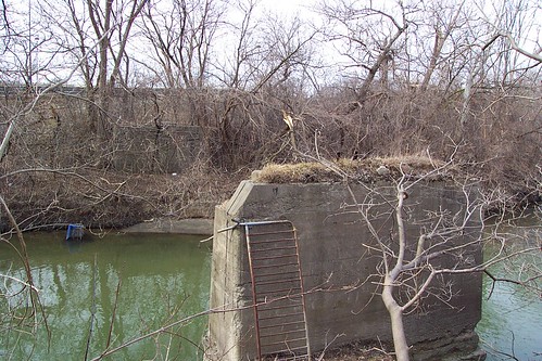
Lawrence Avenue once crossed the Don here via a one-lane pony truss bridge. DVP exit to eastbound Lawrence Ave. seen through trees beyond on far side. Note that this abutment has apparently fallen into the river in the past year or so.
Having nothing else planned, I hung around the archives for a bit and resorted to photographing the aerials. I wanted to see what the area where the building I'm buying into looked like at various times. Most of the neighbourhood was built during the early to mid-1960s, but my building wasn't constructed till 1975. While I was looking at the plates, I decided to have a look at the construction of the Don Valley Parkway. The DVP (and Hwy 404, north of the 401) largely assumed the route (or at least unused road allowance) of Woodbine Avenue from the vicinity of Lawrence Avenue northward. Essentially nothing's been left of that part of Woodbine in Toronto since 1977; it only resumes being a regular street north of Steeles in York Region. So it's kind of weird seeing "Woodbine Avenue" intersections with York Mills, Sheppard, Finch, Van Horne, etc., where there are now just bridges. Seeing homes along a road that's now eight to ten lanes of asphalt. One plate, from 1960, was especially interesting to me. It's been hard, in aerial shots, for me to pick out precisely where Woodbine used to end above the Don Valley. It sort of trails off, literally. A bit of its allowance was used by Lawrence Avenue in its tortuous route crossing the Don. But, Saturday, I finally spotted it. It used to end right here. South of this, it was just valley. Woodbine resumes (and still exists as such) way down here, not counting its short stretch as "Woodbine Heights Blvd" on the little promontory just to the north. But in the 1960 shot, right at the end at the barrier, is this sad, lone little house. And looking at it, I thought, wow, that's sad; it probably got creamed when they put the DVP through a few years later. Then I looked at the 1971 plate, and was stunned to see the house was still there! Its driveway fed from the little road right to the north, serving as parking for the new townhouses. And to my amazement, I'm pretty sure the place still exists, with a few additions, and its driveway now on Geraldine Court. It's this place, right here. Imagine that place at the end of a long country road, surrounded by nothing but trees on the edge of the valley. Now look at it. Driving by, would you ever imagine? I'd love to have a look at this place from the road and try to picture that.
Anyway, after that, I made my way through town to my new neighbourhood. I thought I'd check out the grocery store across the road from my new place. It's a Food Basics, the chain I use most often, and I was really impressed with this one when I went inside. It's easy to imagine getting off the bus in front of it, picking up the couple of things I'd need in an evening, and just walking home, or wandering over first thing on a Saturday morning. I think I'll enjoy that.
Sunday, just for the sake of remembering, I was supposed to visit with Dave in Hamilton. We were going to do the pub in his neighbourhood at noon. He had to back that off to late afternoon so I decided to make a virtue of necessity and suggested to my folks that I swing by. I could show them the cheat sheets for the place I was buying. Then Dave had to cancel altogether so it morphed from a trip to see him to a trip to see my folks. I was there four or five hours; it was a nice little visit. Probably see Dave in a couple of weeks.
1 comment:
Seeing an abandoned pier like the one in the photo ALWAYS makes me wish for a photo of the bridge that it used to support. I'm about to the point where I don't want to see any more abandoned piers (or abutments) unless I know I can get that old photo!
Post a Comment