


Fifth Line West, south of Hwy 401, MapArt
For years now I've had this interest in old, abandoned roads. I don't know for sure what it is. Maybe it's the fascination and slight horror I find in the idea that a public place, once so important, can not only be eclipsed by improvements, but fall into disuse and, in fact, be completely forgotten, or forgotten by all but a few hikers and dog-walkers.
Given the nature of blogs, I have to post these in reverse order for them to make any sense. So I guess it's only fair that I post last the thing I found first.
Back when I was university, I was out driving with a buddy of mine in our neighbourhood. We were just wandering around, killing time on a Saturday. We came to what was then the end of Aquitaine Avenue, which at that time terminated in a cul-de-sac with a short, crumbly road running from it, which itself ended a few dozen yards south at a creek. The sign gave the name of the stub as Fifth Line. I knew that most of the major north-south streets in Mississauga were once numbered concession lines (McLaughlin was once First Line, Creditview was Third...). But this one? To our backs was the 401. Obviously this particular road had been bisected by the superhighway in the 50s and never bridged. I went home, consulted a map, and realized that this little chunk of road had once been part of one of those concession lines. South, it had become Erin Mills Parkway, a major thoroughfare. But the section between the 401 and Battleford Drive had been erased between the mid-70s and the mid-80s. The little strip in these photos was all that remained.
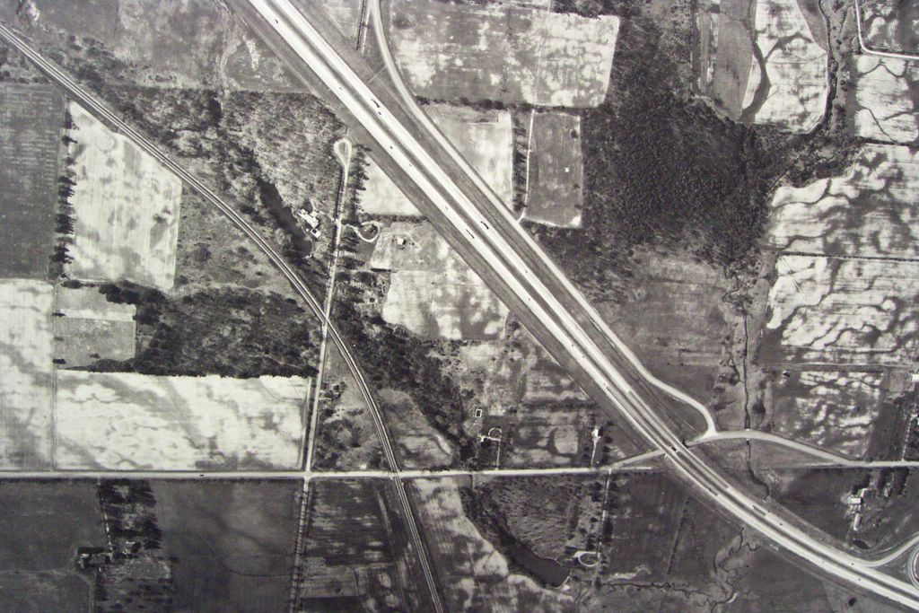
City of Toronto Archives, 1967, plate 188 detail
To orient the image: north is at the top. The broad diagonal path is Highway 401, today the busiest superhighway in North America. The horizontal east-west road near the bottom is Derry Road. Running north-south at centre-left is Fifth Line West. All sections you see here south of the 401 are closed, including the section immediately south of the highway, which is being discussed here. The property of Bill Arch is between the railroad line and the 401, west (left) of Fifth Line...
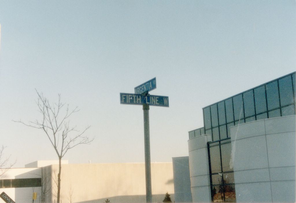
Corner of Fifth Line West and Argentia Blvd., winter of 1990-1991
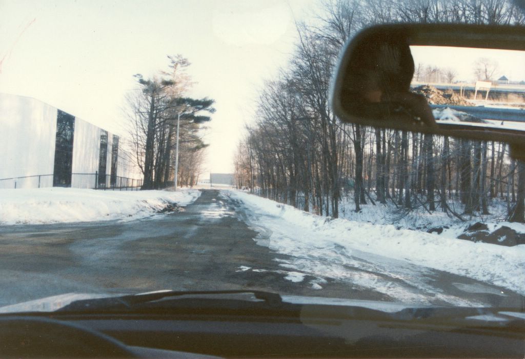
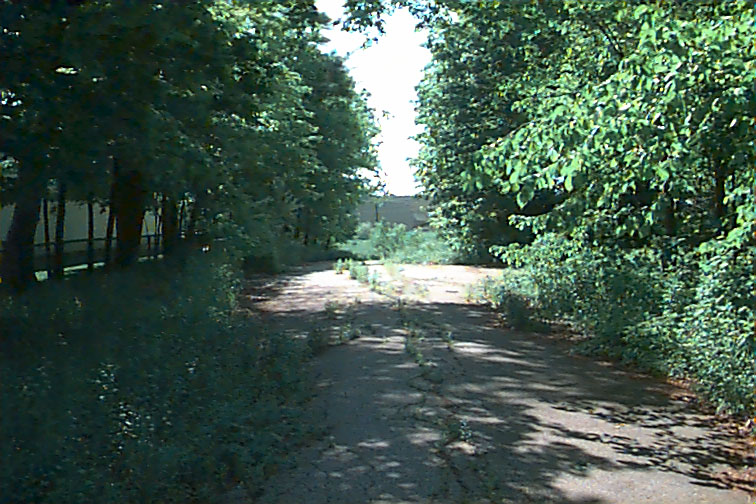
Looking south down Fifth Line West, winter, 1990-1991

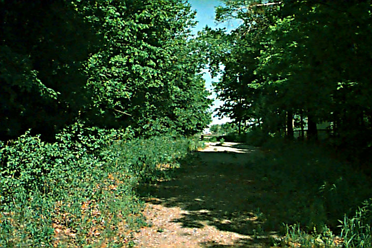
Looking south, 1997 or 1998

Closed, Feb. 2002
Even this little chunk has slowly been debilitated. When I first found it in 1990, I could (and did) drive it all the way to the lip of the creek. By the mid-90s, first portable concrete barriers and later permanent wooden ones were erected half way down. You can see them in some of these shots. Then, a couple of years ago when I was passing through in the winter (2002, I think), I noticed the road had finally been closed off to vehicles for good. Large boulders had been placed at the mouth of the street where it connected to Aquitaine, by then a through street all the way to Winston Churchill Blvd.

Looking north, 1997 or 1998
Passing through again on the weekend, I got the biggest shock of all. The road is now entirely gone. Closed, it’s apparently been sold to the adjacent properties. The warehouse it once ran beside has consumed it for its parking lot; the stand of trees that once lined the east side completely gone. I could hardly believe it. These two views are essentially the same, except that I’m probably standing a few yards further right in the new shot. They’re separated by about seven or eight years. The road’s completely gone; not a hint of it remains. No one will ever again stumble upon it, wonder at it, glance at a map and ponder the history. The whole reason the road survived so long is that the other property, which is still treed, was once the home of Canadian general who fought in the Second World War, a man named Bill Arch, who had a lumber business that was (last time I checked in the 90s) still a going concern in Streetsville, due south of these shots. He had a large home in the copse there, with a duck pond that’s still there, and in 1990, his driveway and pillars at its entrance were still there. There’s not a hint of it now.
Looking north towards the 401, 1997 or 1998

Looking north towards the 401, 2005
Looking south towards the creek, railroad tracks, warehouse, and Derry Road, 1997 or 1998

Looking south towards the creek, railroad tracks, warehouse, and Derry Road, 2005
I find such losses of communal memory wistful, generally. But this one has a personal sadness to it. In the mid-90s, I stood with a buddy of mine out there one summer evening. His marriage was coming to an end, and we’d gone out there to talk about his plans. He was about to move out to British Columbia, where his folks were, and I stood there knowing that, odds are, it was one of the last times we would have together. While we were there, the Northern Lights appeared. It’s the only time in my life I can actually remember seeing them. They were beautiful, and they really do make a sound. Like breath, or soft wind, but not quite. They make you feel like a momentary blip in something much more ancient and permanent in a way the stars are much too ever-present to really manage. And I stood there with this high school chum about to disappear from my life, watching these sheets of pink, blue, and green shift above us, shielded from the city lights by the trees, just listening. And now even the place itself is gone.
The following is information I compiled about the property on the west side of these shots (the area in trees in all shots, opposite the warehouse) in October of 1990...
COMPILED INFORMATION CONCERNING
FIFTH LINE WEST, PEEL REGION
AND A CERTAIN PROPERTY THEREON
Began investigation Saturday, September 15, 1990 (returning from Cooksville and following Argentia Rd. to its intersection with Fifth Line West in the company of a friend; stopped to investigate Argentia-extention to Winston Churchill Blvd. under construction and stumbled upon remnants of demolished property with driveway on Fifth Line West).
Telephone poles and manhole covers on Argentia Rd. north of Derry Rd. dated 1982; probable construction date: map dating from 1979 does not show Argentia crossing Derry Rd.
Telephone poles on remnant of Fifth Line West south of 401 and north of Derry Rd. dated 1954; spikes in them read "HEPC [(Ontario) Hydro-Electric Power Corporation] 55", possibly the installation date (1955?). Possible extention of Hydro service up Fifth Line West at this time if not sooner (???).
Highway 401 opened in Peel in two segments. Between Highway 10 (Hurontario St.) and Highway 27, the 401 opened on November 3, 1958. Further west, between Highway 10 and Highway 25, the 401 opened a year later on November 26, 1959; this is the section that intersects Fifth Line West. Maps prior to the 1950s show Fifth Line West here as a through street. South of Britannia Rd., Fifth Line West was County Road 18. Fifth Line West formerly made a correction several yards to the northwest at Eglinton Ave. (formerly it ran through what is now the Credit Valley Hospital); this correction was smoothed into continuity by a gentle curve as it now exists on Erin Mills Pkwy.
According to 'A History of Peel County', the 401 "crossed Peel in 1952". Presumably this is when construction began and when Fifth Line West was interrupted.
Fifth Line West at one time ran unbroken between the 401 and Britannia Rd. Between Battleford Rd. and Derry Rd. it ran along what is now the border between Meadowvale's east residential boundary and its west industrial boundary. It was deleted in sections according to by-laws; the section between the corner of Battleford Rd. and Erin Mills Pkwy., and Surveyor Rd., was closed by By-Law 904-81 (81, presumably, is the year of the order); the section between Surveyor Rd. and the corner of Millcreek Dr. and Aquitaine Ave. was closed by By-Law 740-83; the section between Millcreek Dr. and Derry Rd. was closed by By-Law 141-75. North of Derry Rd., Fifth Line West was cut back to its present dimensions (and separated from Derry Rd.) by By-Law 637-83. All these deletions post-date Mississauga's incorporation in 1974.
Manhole covers on Surveyor Rd. date to 1975; it appears on a map dated 1979, intersecting a now-deleted section of Fifth Line West.
The house was probably never serviced with sewage or storm drains; the City has no records of existing or abandoned drains in that area that would have serviced the residence. There is a large, loose patch on the property that could alternately have been either a basement or, it seems more likely, a septic tank.
The property in question is HSW Concession 6, Lot 11. Records from 1877 show the property as part of a larger property stretching from Winston Churchill Blvd. to Fifth Line West, along Derry Rd. and as far north as the point that the 401 intersects Fifth Line West; its is noted as belonging to one Mrs. Isaac Waite. On the property is a house, just to the east of a church, both fronting on Derry Rd. (the church was torn down within living memory; today there is a parkette there; directly across Derry Rd. there is a small cemetery).
The last recorded residential owner is one William C. Arch, recorded as owner and resident in a 1978 survey for 1979 taxation purposes. His mailing address is given as "85 Queen St. N., Streetsville, ON, L5N 1A4. The property is presently, and was then, a wedge of 9.8 acres in the eastern quarter of the land recorded as Mrs. Waite's (in 1877), widening from a point as it heads north. The map from 1979 records a lone structure on the west side of Fifth Line West between Derry Rd. and the 401; although there are several on the east side (where the Canara building now sits). There was also, according to the record, a tenant on the property; there were two tenant portions on the property on record.
The property's deed now resides with the Erin Mills Development Corporation. It now fronts on Argentia Rd., with the address 2785 Argentia Rd., leading one to wonder if the remaining section of Fifth Line West in question is shortly to be deleted as well.
A well-drilling record for the property exists as follows:
Hurontario St., West Concession 6, Lot 11 Well #49-2690; easting 599670, northing 4828042 Elevation 640'
Drilled July 24, 1962, by licence holder 1307 Fresh water at 20'; 75 GPM; domestic use 30" diameter
Brown topsoil to 10', then gravel; well depth 30' Owner, Bill Arch
License 1307 held by Maurice Babiuk
361 West Mall, Apt. 304 Etobicoke, ON
According to Bob Bell, Supervisor of the Northern District (with whom I spoke Oct. 2, 1990; reference, telephone no. 677-0181), Bill Arch was a general in the army; he kept a garden on the property which he tended himself; the pool formed by the stream running through the property was a duck pond; he owned a lumber business called Forest Products on Mississauga Rd. below Derry Rd. near the railroad tracks. Mr. Bell says Fifth Line West was never paved, but was a "Grade B surface" road. Mr. Bell has worked for the City out of the Streetsville office for sixteen years (probably since the Incorporation).
Forest Products is listed in the phone book as 826-1117, with the address of 85 Queen St. N. (Mississauga Rd. is called Queen St. where it runs through Streetsville, since Streetsville was, up till 1974, a separate town). This is the same address as the mailing address on Bill Arch's 1978 survey record.
Another interviewee recalls a struggle to remove "an old man" from the nub of Fifth Line West sometime in the early 1980s (possibly 1982 or 1983); she identified the property in question as this same contested property to her brother, Alan. The property had been re-zoned as industrial by then; the City was probably attempting to secure the land from Bill Arch at the time. This would explain the deletion of Fifth Line West north of Derry Rd. in 1983 stopping exactly at the southern edge of the property's driveway. Presumably the house (along with whatever structures accompanied it) was demolished sometime after 1983.
MISC. HISTORICAL NOTES
Toronto Township was named in 1805.
The survey of the northern section of Toronto Township was completed on Oct. 1, 1819, by Richard Bristol, partnered with Timothy Street (founder of Streetsville); herein is the origin of Fifth Line West.
Toronto Township became the Town of Mississauga (named by a vote in December, 1967) on Jan. 1, 1968.
To counter the territorial claims of the Towns of Streetsville and Port Credit in 1973, the Town of Mississauga counter-sued to annex them and form the City of Mississauga. It succeeded; on Jan. 1, 1974, the City of Mississauga and the Regional Municipality of Peel were proclaimed. Mississauga lost Churchville and half the land between Steeles Ave. and the 401 to Brampton, but acquired Streetsville and Port Credit, as well as Halton's Tenth and Eleventh Concessions between the 401 and Dundas St. Otherwise the external boundaries of Peel County did not change with the inception of the Region.
In March, 1989, Peel Region, along with the regions of Halton, York, Metro, and Durham, formed the Greater Toronto Area. Ruth Grier was named the first Minister Responsible for the GTA on Oct. 1, 1990.
1 comment:
Fantastic work on this portion of the Fifth Line W.
I have lived in Mississauga for about 35 years and can remember when portions of the Fifth Line were visible to the south off Erin Mills Parkway.
This summer (2013) I have set out to document photographically in Google Earth what visual evidence remains of the Fifth Line West right of way north through Mississauga.
This is still a work in progress although I have uploaded the first batch of photos to Google Earth for review recently.
I have used just memory in trying to locate where Fifth Line ran.
Great photos and research!
Neil Lafleur
I don't check my gmail, so I am reachable at neil_lafleur@rogers.com
Post a Comment