


Ninth Line bridge map, MapArt
Everything here really stems from that Saturday afternoon in September of 1990 when I “discovered” Fifth Line. Ever since then, I’ve been fascinated by maps, aerial photographs, and looking into the changes in the road grid of the city over time. I’m always moved by the things that get left behind, disused, relegated to history, slow decay... once-important parts of human public life being swallowed up again by nature.
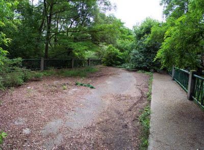
Sometime in the 1990s I noticed there was a little gap in Ninth Line down by the Ford plant at the Queen Elizabeth Way (more commonly called the QEW). I drove down there one afternoon and was completely amazed to discover a bridge completely hidden by the trees, but otherwise literally in sight of a major intersection. It was fascinating reminder of all the hidden things peppered all around us that we never see because nature so completely cloaks her work of reclamation.
Ninth Line bridge
I went back there on the weekend. It’s only the second time I’ve been there, and it’s been most of decade at least since last time, so aside from knowing there was a bridge there, it was a lot like finding it for the first time. I parked south of it on the unused, cul-de-sac tail end of Ninth Line, and stepped into the forest. It was only about fifteen seconds into the woods, and I didn’t even see it till I was right on top of it. Literally! I happened to glance over to the left and caught sight of one of the big concrete anchors to the guard rail, and I actually said, “Oh!”. That’s how completely hidden in the trees this place has become.
It’s the dream of every child who ever had a big imagination. I wish I’d had it when I was ten. Surrounded on trees pressing in from all sides, the bridge stands over a gorgeous, briskly-running stream called Joshua’s Creek. The road surface still exists, but it’s clear that it will eventually be covered with grass and then lost in brush. But as I remarked to a friend when I told him about it, at the moment it would make a wonderful bridge to the Enterprise, or landing deck of an air craft carrier, or any other number of fantastic settings a band of kids could come up with, if they only knew it was there. And it’s smack in the middle of civilization on all sides; a golf course immediately on the west, a major road to the east, a car factory to the south, and subdivisions to the north.
Looking north
Looking south
I don’t know exactly when this bridge was abandoned, but a map I have shows it still in use in the mid-70s. By 1990, it had been circumvented and was no longer on the map. A water main cover at the south end has the date 1987 on it, which suggests to me major construction was going on there about that time, so it was probably closed around then, not quite twenty years ago. I’ve seen a lot of abandoned little bridges, and they all tend to be ancient, one-lane deals that obviously were of use to rural communities with light traffic, but which had to be given up once urbanity rolled up. But this bridge is wide; two lanes, and sidewalks up both sides. While not equal to the traffic that runs from Ninth Line to Ford Drive now, it must have been a comparatively modern bridge in the first place. Strictly at a guess, I’d say it was built in the 1960s; no earlier than the late 50s. As bridges go, it had a pretty brief career. Now it’s been handed over for nature to look after. There’s enough of a footpath in and out that I can see it’s still being visited by a few people. But there’s no garbage on it, and even what little graffiti I did see looked old and faded. If it’s still in use by pedestrians, there aren’t many. Quite a change for a bridge that once probably carried scores or even hundreds of cars a day less than a quarter century ago.
11 comments:
There is no beauty greater than an old, abandoned road.
I lived in the Meadowvale area as a student in 1982-1983 and we would amuse ourselves by walking up the fifth line from Battleford to the 401. There was a signal at the railroad tracks.
I haven't been back there in 20 years. I had no idea it's completely gone.
I lived in the Meadowvale area as a student in 1982-1983 and we would amuse ourselves by walking up the fifth line from Battleford to the 401. There was a signal at the railroad tracks.
I have friends who lived there at the time... I didn't move there till a few years later and never noticed much beyond Meadowvale Town Centre till the very late 80s, or 1990, when I first discovered Fifth Line. By that time, it was completely closed between Battleford and the 401, with the exception of that little stub connected to what was then the end of Aquitaine Avenue (I actually learned to drive, maneuvering between traffic cones, on that stretch of Aquitaine in the late 80s because there was no traffic on it at the time). I can't imagine what Fifth Line looked like when it was still open... I've always wondered. The level crossing at the tracks was long gone by the time I found the place. The road died at the creek running from the duck pond. Obviously there was once a bridge or drainage tunnel there at one time, but it was removed and the creek was an open course by 1990, and there were no RR signals at the tracks that I can recall. I have a friend who still lives in Meadowvale who had an acquaintance who actually lived on Fifth Line just north of Derry. That house is, of course, long demolished (there's a warehouse covering the road allowance north of Derry now), as is, incidentally, the little schoolhouse or church that once hugged the northwest angle formed by Derry and the 401; it lasted until some point in the early 90s. You'd probably be rather surprised by the new course of Derry Road itself between Mississauga Road and Mavis Road (and yes, there is a corner of Derry and Mavis now -- Mavis goes all the way up into Brampton today).
I've been planning to add another road segment lately but haven't gotten around to it. Watch the blog if you've a mind to. :)
Oh yeah, when I lived there, there was a short two-lane segment of Erin Mills Parkway between Thomas and Battleford still signed as "Fifth Line." The name was changed when they twinned that stretch into four lanes.
I recall walking the tracks (at maybe 2:00 AM -- I was a University student, it was the middle of my day) from Fifth Line all the way out to nowhere, where they crossed a narrow two-lane road that was Winston Churchill. I could have sworn I had walked to Milton.
I was aware of the new course of Derry road since it was a part of the Official Plan, and they had started to replace the two-lane tunnel under the 401 when I left the area.
Creditview, on the other hand, goes nowhere near where it did when I live in the area.
I recall walking the tracks (at maybe 2:00 AM -- I was a University student, it was the middle of my day) from Fifth Line all the way out to nowhere, where they crossed a narrow two-lane road that was Winston Churchill. I could have sworn I had walked to Milton.
Boy, things have sure changed around there. Around the time I got my license, they built an interchange between Winston Churchill and the 401. But those railroad tracks were a level crossing till 1994, I think. I can recall a couple of occasions coming home from downtown late at night, getting off the 401 at Winnie, and then having to sit there for five minutes while a freight train passed. Now there's a Wal-Mart there, accompanied by a number of other box stores. They're fed by Aquitaine, which now reaches all the way west to Tenth Line. Just a few years ago, Tenth Line north of Derry was a dead-end road all the way to the 401. I can remember back in high school when the northwest corner of Derry and Winston Churchill was still woodlands. Subdivisions have just poured over the land, all the way to the border at Ninth Line...
Creditview, on the other hand, goes nowhere near where it did when I live in the area.
I remember the weird little dogsleg at Creditview and Derry, complicated by the level crossing in the middle of the intersection. Even in those days, Creditview took a slight deke; there was abandoned pavement off to the side. I can remember driving up Creditview to the park in Churchville. They heavily reworked Derry... first, to correct the dogsleg created at Mississauga Road, and then, diverting it wildly off to the north through the conservation area, completely bypassing Meadowvale village. It was around that time that they closed off Creditview between Derry and the newly-built 407. I visited the closed section in 1999... it's probably overgrown by now.
Wish I could have seen it all in the early 80s. Must have been something to remember.
Wish I could have seen it all in the early 80s. Must have been something to remember.
Well, it was ruralish.
Aquitaine and Battleford both stopped at the Meadowvale Town Centre, and there was nothing but fields between Brittania and what later became the 403.
When I first moved to Mississauga in 1981, they had just completed the Burnhamthorpe bridge over the Credit river. One day I walked from Edrindale College (I was a student) to Square One (which was actually square) along Burnhamthorpe. It was fields on both sides all the way: Square One was surrounded by fields, with fields to the east and south -- to the southeast there were apartments. In the late '80s I lived in one of thoses apartments for a few years, and by then Burnhamthorpe was pretty much all built up.
Then again, I lived on the West Mountain in Hamilton until I was 12 and played on the escarpment where the 403 now goes. And the farm my Wife grew up on is now under the asphalt of highway 416. Such is progress.
I now live in a really rural area (too much Mississauga is good for no man). Highway 7 runs nearby, and it's been realigned a few times. I always get a kick out of tracing it's former path through the fields and woods beside the existing road as I drive it.
--smw
Aquitaine and Battleford both stopped at the Meadowvale Town Centre, and there was nothing but fields between Brittania and what later became the 403.
Oh, hell, I've been saying "Aquitaine" all this time when I meant "Argentia". Sorry about the confusion. Wouldn't have made that mistake just a few years ago... :/
When I first moved to Mississauga in 1981, they had just completed the Burnhamthorpe bridge over the Credit river.
Ah, the Burnhamthorpe bridge. :) When I first got interested in old roads, Burnhamthorpe was one I had some interest in. Taking the bus to Erindale, I used to pass a little chunk of what once was the end of Burnhamthorpe at Mississauga Road... today it's called Woodchuck Lane, and isn't a through street. Of course, they diverted it south and then vaulted the river with that fantastic bridge to complete the road. That was a while before I arrived in Mississauga. I was still living on the west side of Hamilton Mountain at the time. Ironies abound. :) I have an aerial photograph of the west end of the Mountain from 1954... before the schools I went to or the home I lived in had been built. It's weird. When I look at that photo, imagining the mid-50s, it's like imagining the world just starting up, only a little while after it was created, and the human race just taking it over...
Yeah, Hamilton is nothing like it was when I was a kid. In fact it wasn't much like that when I was a kid.
I have memories of a strip of seedy bars and shops along the south side of York street where it intersected James street. The northwest corner of that intersection was a park where the city hall had been in the 1950s. North of there was Eaton's, where the elevators had glass doors and human operators who would call out the floors, open and close the doors, and make the cars go up and down with a hand lever. Oh, and they had these cool pneumatic tubes all over the store. Cool stuff for a little kid.
That area is now all underneath Lloyd D. Jackson Square.
I have pictures from the early 1960s of the neighbourhood where my parent's first house was being built. I image it was 1961 or so. That would have been in the West 20s I guess. My mother taught at Westmount Secondary School, which sat in a field. You would get to it by taking Garth Street, which was an oiled gravel road south of Mohawk Avenue and ended at Stone Church Road. In fact, a lot of the non-arterial roads weren't paved until the mid to late 1960s.
If I recall, Rymal Road went straight across, but in the 1970s it was curved to the north when all the houses went in. Later, when the Linc went in, it was obvious why it was rerouted. Man, someone had pretty long-term vision in those days.
--smw
I have memories of a strip of seedy bars and shops along the south side of York street where it intersected James street. The northwest corner of that intersection was a park where the city hall had been in the 1950s. North of there was Eaton's, where the elevators had glass doors and human operators who would call out the floors, open and close the doors, and make the cars go up and down with a hand lever. Oh, and they had these cool pneumatic tubes all over the store. Cool stuff for a little kid.
That area is now all underneath Lloyd D. Jackson Square.
My experience of Hamilton downtown dates from the early 80s when we used to catch Sanatorium Saturday mornings to go play video games down on the stretch opposite Gore Park (before they wrecked it). Lloyd D. Jackson Square was just a feature of Hamilton for me... I had no experience of what was there before.
I have pictures from the early 1960s of the neighbourhood where my parent's first house was being built. I image it was 1961 or so. That would have been in the West 20s I guess. My mother taught at Westmount Secondary School, which sat in a field. You would get to it by taking Garth Street, which was an oiled gravel road south of Mohawk Avenue and ended at Stone Church Road. In fact, a lot of the non-arterial roads weren't paved until the mid to late 1960s.
Fascinating stuff. I moved to Hamilton about 1980, when most of that development was already finished... though there's been a lot built up south of where I lived along Upper Paradise. I hardly recognize the place now.
I nearly went to Westmount... well, actually, the middle school that accompanies it whose name I forget now. It was similar to Westmount, though... "west" something, as I recall. Westdale? Anyway... we lived briefly on Limeridge when we moved there before heading out the 1970s developments of which you speak. Instead, I went to an elementary school down in the neighbourhood you lived in for grades 7 and 8, and eventually wound going to SAM before we left for Mississauga.
Garth was already paved and a main street by then, and Limeridge made that weird deke north before joining it... Fortino's used to be on the deke, as I remember. I'm told it was their first location. The aerial photo I have from '54 shows Limeridge connecting directly to Garth though what eventually became a set of townhouses a high school buddy of mine lived in in the late 1980s. Given that I saw it later than you, Garth always went to Rymal in my experience (with that awful stretch south of Stone Church), but now it's been extended south to Twenty Road. I imagine eventually it'll go all the way to the airport, or thereabouts.
If I recall, Rymal Road went straight across, but in the 1970s it was curved to the north when all the houses went in. Later, when the Linc went in, it was obvious why it was rerouted. Man, someone had pretty long-term vision in those days.
I don't mean to correct you, particularly since your experience of Hamilton is almost certainly much broader than mine, but I wonder if you mean Stone Church? When I was living there, Stone Church used to curve north to become Upper Horning. The bus used to take us to school down Upper Horning to Mohawk, Rice, Sanatorium... I remember when they did some work on Upper Horning to favour one of the roads in the subdivision... suddenly, you had to turn off Upper Horning to continue down Upper Horning! That always struck me as idiotic until the day I drove up Upper Horning to explore my old neighbourhood and found it a dead end at the Linc. Obviously, a road of so little consequence that they didn't even build an underpass. That made me a little sad. Stone Church, on the other hand, has had a renaissance because of it... freed from its marriage to Upper Horning, it has a new destiny and pushes all the way through to Golf Links Road... another forgotten, "nothing" street when I was a kid that's gone on to the big time today.
I'm rather taken with the expressway because the house I lived in backed onto the road allowance for it. I used to have to cross it to get to high school. At the time, it was a copse of trees (the last remnant of a huge triangular stand in the 1954 shot) at the edge of a field on a hill. All that's completely gone now, which is unfortunate, at least inasmuch as it was overrun with paths and places the kids used to play. But I can't say I'm much impressed with the job they did planning it. It's made an gratuitous and unforgivable ruin of Limeridge Road. Since they planned it in the 60s when virtually nothing was there, there's no reason they couldn't have slotted it 50 yards further south and spared Limeridge being vivisected by the interchanges. That was just bad planning. They gave up two (or more) cross-town lanes for four... but they could have had six. I discovered all this in the most pragmatice of ways... after they built the highway I was visiting relatives on the Mountain (in 1998, I think) and decided to go poking around my old neighbourhoods to see how they'd changed... I used Garth to accesses Limeridge. After checking out the place I lived in on Limeridge, I decided to head back to the east side where my relatives where. I was just about to go through the intersection at Limeridge and Upper James when I realized there WAS no intersection at Limeridge and Upper James. I had to stop at fence, watching inaccessible traffic streaming by up and down Upper James on the other side. It was a definite Twilight Zone moment. I must have sat there for a minute or two in the cul de sac that used to be a major intersection, trying to get it to sink in. It was just unbelievable.
Incidentally, for what it's worth, I added a posting about Derry and Creditview featuring some shots I took there in 1999 when the work closing it up was being completed. It's on the home page of the blog (at the moment, anyway... otherwise, it'll be found on the October page). You can access it here if you're interested. :)
Erm... for "pragmatice" above, read "pragmatic". :)
Curse the inability to edit comment postings in this thing! :/
I went to an elementary school down in the neighbourhood you lived in for grades 7 and 8, and eventually wound going to SAM...
Sounds like Chedoke Public School, which I attended from K to 5 (when we moved further west) and again for grade 7 (after which we moved out of town completely). I understand it's Chedoke Middle School now, no more K to 5.
I remember when they built SAM, smack in the middle of a field where we would go to catch frogs. The field was bounded by Upper Paradise (which ended at highway 53), Stone Church/Upper Horning on the south and west -- both of them gravel well into the mid seventies -- and a two-lane Mohawk Road. There was an abandoned farm house fronting on Upper Paradise we could play in. We also played in the construction site when they built the school. I suspect the level of supervision kids had in those days was less than we insist on now.
I don't mean to correct you, particularly since your experience of Hamilton is almost certainly much broader than mine, but I wonder if you mean Stone Church? No, I meant Limeridge. It's been a lot of decades since I've done anything but drive through that area. I have a brother who lives downtown but I live 6 hours away, so I never get there anymore. So it goes.
Anyways, thanks for bringing back all these memories.
Sounds like Chedoke Public School... I understand it's Chedoke Middle School now, no more K to 5.
You got it, Pontiac. So they axed the elementary grades? Interesting. When I was there (and probably when you were there), the north-south two-storey wing was for the 7s and 8s... the east-west wing along Bendamere (am I even spelling that right?) was for the K-5 crowd. Intriguing how it's changed.
I remember when they built SAM, smack in the middle of a field where we would go to catch frogs.
Wow, that's hard for me to even imagine. The place was entirely built-up by the time I knew it. There was the mall, Magnolia and the rest of the maze of streets, and all the homes around it. About the only change was the building of a church and set of townhouses in the big open field along Mohawk between Magnolia and Upper Horning. I remember while I was going there we identified one of our teachers in a hallway photograph of student councillors from the late 1960s. We knew it was him, though we never actually got him to own up to it. :)
The field was bounded by Upper Paradise (which ended at highway 53)...
Now that I do remember. When I was living there, Upper Paradise still ended at Rymal Road. The corner of Upper Paradise and Stone Church was still undeveloped, except for a gas station and a corner store. I remember being led up there as a teenager by a friend who wanted to show me something he'd found in the southwest field... I forget what it was, but I do remember the mud was knee-deep and we nearly ended up losing our shoes. Now the place is an apartment building, I think... has been for many years, though.
There was an abandoned farm house fronting on Upper Paradise we could play in.
Was that the one immediately north of the clearing where the Linc was eventually built? I do remember an abandoned house fronting on Upper Paradise's west side there. I was never in it, but it stood for a couple of years after I moved there. I used to have to pass it on my way to Westcliff Mall.
No, I meant Limeridge.
I've never been able to figure out exactly why they diverted Limeridge at Garth that way. I suppose it might have had to do with the eventual construction of the interchange at Garth, but that would imply they knew all along the price Limeridge was going to have to pay to build the highway. But now that I think about it, they must have. I remember there was an abandoned gas station or something on the southeast side of Limeridge and Uppper James even when I moved there, and for years I wondered why no one was building at such an obvious business location. Well, now I know. I even remember visiting friends of my parents at a house with a pool just opposite, back in the early 80s. It's gone now, replaced by the offramp.
Post a Comment